Explaining fire-driven landscape transformation during the Initial Burning Period of New Zealand's prehistory
Abstract
At the time of Māori settlement, ca. 750 years ago, New Zealand's ecosystems experienced catastrophic change, including the introduction of fire to ignition-limited ecosystems and the resulting widespread loss of forest. While high-resolution sediment-charcoal analyses suggest this forest loss was rapid, Māori populations were small and transient during the Initial Burning Period and there is evidence for widespread fire activity in places where there is little archaeological evidence of human presence. These observations beg the question ‘how did small populations manage to transform large areas so rapidly?’ Using a simulation model, we demonstrate how the relationship between time since fire and flammability in New Zealand's forests drives positive feedbacks that allow for rapid and extensive deforestation. Under ignition scenarios mirroring prehuman conditions, the model did not produce significant deforestation – thus, it is extremely unlikely that deforestation could have occurred without human-initiated burning. Scenarios where ignition was spatio-temporally random also failed to result in deforestation. Rapid and widespread forest loss occurred in scenarios incorporating spatio-temporally savvy selection of ignition locations. Targeting ignitions in flammable vegetation was more important than targeting ignitions in years with favourable climatic conditions. However, targeting in space and time concurrently, such that flammable vegetation was ignited during favourable climatic years was the most efficient strategy of those simulated. Following the Initial Burning Period decadal ignitions would have been sufficient to maintain a deforested shrubland/grassland landscape. New Zealand's Initial Burning Period is one of many that occurred across eastern Polynesia following human settlement, and these events have left long-term legacy effects that remain evident in contemporary landscapes. Improving understanding of how humans shaped environments in New Zealand in the past has implications for eastern Polynesia as a whole.
Introduction
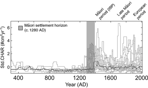
Although New Zealand's landscapes may have had biophysical conditions conducive to fire, fire frequencies before human settlement were extremely low due to infrequent natural ignitions that were typically associated with heavy rainfall events (Ogden et al., 1998; Perry et al., 2012). At the time of Māori settlement of New Zealand, ca. 1280 ad, approximately 85–90% of the landmass was forested, with fire activity dramatically increasing after settlement (McGlone & Wilmshurst, 1999; Wilmshurst et al., 2008). On the basis of high-resolution sediment-charcoal records from 16 lakes across the South Island of New Zealand, McWethy et al. (2009, 2010) argue that there was a short (possibly as little as 100 years), but site asynchronous, period of intense burning around the time of settlement (the Initial Burning Period), which resulted in 40–50% forest cover being lost (Fig. 1). On the basis of two detailed pollen records from Hawkes Bay in the North Island of New Zealand, Wilmshurst (1997) estimates that deforestation was complete within 60–155 years, with forest loss more rapid on drier sites. Following the Initial Burning Period the abundance of macroscopic charcoal in lake-sediment records declines, reflecting the clearance of tall forest trees, but microscopic charcoal particles (<125 microns) remain relatively abundant at most sites (McGlone & Wilmshurst, 1999). The persistence of grassland and shrubland with shade-intolerant bracken fern (Pteridium esculentum Dennstaedtiaceae) following Māori settlement implies recurrent fire following the initial burning period and accounts for the presence of finer (<125 microns) charcoal particles (McGlone & Wilmshurst, 1999; McGlone et al., 2005). Genetic analyses suggest that the founding population of Māori in New Zealand was unlikely to have been more than 200 female individuals (Murray-Mcintosh et al., 1998), and population densities were possibly 30× lower in the South Island than the North Island (McGlone et al., 1994). Given that this is the case, it is difficult to explain how early Māori effected the magnitude of ecological change suggested by the palaeoecological record (e.g. McGlone, 1983, 1989; McGlone & Wilmshurst, 1999; McWethy et al., 2010). Possible explanations range from repeated burning at every opportunity to more selective use of fire in time and space.
While palaeoecological records, such as those described in McWethy et al. (2009, 2010), provide high-resolution reconstructions of fire activity at the time of Māori settlement, they are acausal and do not reveal the mechanisms driving these dynamics. Although there are scale-related challenges in comparing model simulations with palaeoenvironmental data, simulation models have the potential to explain the changes revealed in the palaeoecological record (Anderson et al., 2006), and data-model comparisons can improve understanding of the mechanisms that cause past environmental change (Peng et al., 2011). For example, Brubaker et al. (2009) used a coarse-scale simulation model (ALFRESCO) to understand possible climate–fire relationships apparent in Holocene sediment-charcoal records from Alaska. In New Zealand, McGlone et al. (2011) used a forest-ecosystem process model (LINKNZ) to explore the effects of past precipitation and temperature seasonality on forest composition during the early Holocene, and compared the model results to actual fossil assemblages and pollen-based climate reconstructions.
- What type of fire regime led to the 40–50% forest loss that occurred during the Initial Burning Period?
- Was selective use of fire in time and space by Māori necessary to transform New Zealand's forest landscapes to shrubland and grassland during the Initial Burning Period or were frequent random ignitions sufficient?
- Under different ignition scenarios, what was the most likely duration of the Initial Burning Period?
- After the Initial Burning Period, what type of fire regime was required to maintain New Zealand's landscapes in a relatively unforested condition until the time of widespread European settlement?
We use a spatially explicit simulation model, which phenomenologically represents the relationships between vegetation and flammability, to explore the outcomes of different human-initiated ignition scenarios (i.e. random vs. targeted timing and placement of ignition in the landscape) in terms of forest loss. Although simulation models have been used to explore prehistoric human fire–vegetation interactions elsewhere (e.g. Colombaroli et al., 2010; Keller et al., 2002; Perry & Enright, 2002a), they have not previously been used in New Zealand.
Materials and methods
Model description
The disturbance regime
We used a spatially explicit simulation model of fire spread motivated by percolation theory, similar in design to those described by Ratz (1995), Perry & Enright (2002b), Zinck & Grimm (2009) and Millington et al. (2009) among others. Our model is spatially explicit and uses a lattice representation of space (i.e. grid-based); grid cells are on the order of 100 m × 100 m in size on a grid of ca. 25 × 25 km – this grain is consistent with that used by mechanistic models of fire spread trialled in New Zealand (Perry et al., 1999). The model runs on an annual time-step. Our model provides a simple representation of the fire regime – as influenced by vegetation, fire weather, climate and human activity – it is a general representation of a lowland New Zealand landscape, but is place-neutral and not intended to represent a specific location. For this reason, we do not include the effects of topography on fire spread. Parisien et al. (2011) found topography to have minimal effect on the spatial pattern of burn probabilities in boreal forest and Cary et al. (2006) found that climate and weather typically override terrain effects in landscape-fire-succession models; both Cary et al. (2006) and Parisien et al. (2011) argue that, where terrain is important, it is via its indirect effects on climate. Although other landscape-level disturbances are of ecological significance in New Zealand's forests, including earthquakes (Wells et al., 2001), volcanism (Wilmshurst & McGlone, 1996; Ogden et al., 2005) and windstorms (Martin & Ogden, 2006), only the fire regime abruptly changed at the time of human settlement, and thus we limit our focus here to fire. The model is implemented in netlogo v 4.1.2 (Wilensky, 1999).
Ignition. In our model we distinguished between fire activity occurring before, during and after the Initial Burning Period. We considered all fire events occurring after human settlement to be human in origin; natural fire events in New Zealand occurred at frequencies at least several orders of magnitude lower than those attributable to humans (Ogden et al., 1998). During each year of the Initial Burning Period n ignitions occur, with n being a random deviate from a Poisson distribution with rate λIBP. Following the Initial Burning Period, ignitions became less common and occurred in any given year with probability pFIRE.
Temporal targeting of ignition in the model was represented by ignitions occurring only when extrinsic climatic conditions (see below) exceeded some threshold value. Spatial targeting of ignition locations was represented by fires igniting the more flammable parts of the landscape such that ignition sites were only selected from the subset of cells that exceed some threshold (e.g. if the threshold was set at 20% then ignition locations were constrained to the 20% most flammable cells). In the absence of any targeting, ignition locations were selected purely at random. Full details of model parameterization for the different scenarios we evaluated are provided in Table 1.
| Experiment | Parameterization | Rationale |
|---|---|---|
| Positive feedback (n = 1260) | Ignition frequency (per year): 0.05, 0.1, 0.2 | Under the moisture model hazard function, to what extent does ‘fire beget fire’? |
| Length: 250 years | ||
| Initial abundance young vegetation: 0.05 to 0.55 by 0.025 | ||
| Prehuman fire (n = 600) | Ignition frequency: 0.02, 0.01, 0.004, 0.002, 0.001 | What is the likelihood of the level of deforestation seen in New Zealand since human settlement occurring under prehuman (Holocene) fire regimes? |
| Length: 2500 | ||
| Initial abundance young vegetation: 0.05, 0.1 | ||
| Targeting | ||
| None (n=800) | IBP ignitions per year: 1, 2, 3, 4, 5 | How effective were spatially random ignitions in driving landscape change? |
| IBP length: 50, 100, 150, 200 | ||
| Initial abundance young vegetation: 0.05, 0.1 | ||
| Space (n=4000) | IBP ignitions per year: 1, 2, 3, 4, 5 | How effective was spatially targeted ignition on the most flammable parts of the landscape in driving landscape change? |
| IBP length: 50, 100, 150, 200 | ||
| Percentile vegetation targeted: 50, 75, 90, 95, 99 | ||
| Initial abundance young vegetation: 0.05, 0.1 | ||
| Time (n=4000) | IBP ignitions per year: 1, 2, 3, 4, 5 | How effective was confining ignitions to times of favourable climate conditions in driving landscape change? |
| IBP length: 50, 100, 150, 200 | ||
| Extrinsic climate threshold (SD above mean): 0, 0.05, 0.10, 0.15, 0.20 | ||
| Initial abundance young vegetation: 0.05, 0.1 | ||
| Time and space (n=20000) | IBP ignition per year: 1, 2, 3, 4, 5 | How effective was an ignition strategy targeting the most flammable vegetation and the most favourable climatic conditions in driving landscape change? |
| IBP length: 50, 100, 150, 200 | ||
| Percentile vegetation targeted: 50, 75, 90, 95, 99 | ||
| Extrinsic climate threshold (SD above mean): 0, 0.05, 0.10, 0.15, 0.20 | ||
| Initial abundance young vegetation: 0.05, 0.1 | ||
| Post-IBP dynamics (n = 7000) | Post-IBP ignition frequency: 1, 0.5, 0.2, 0.1, 0.04, 0.02, 0.01 | What sort of fire regime was required to maintain shrubland/grassland vegetation following the IBP? |
| Post-IBP length: 350, 500 | ||
| Target vegetation? TRUE and FALSE | ||
| Percentile vegetation targeted: 50, 75, 90, 95, 99 | ||
- In all cases, the edge effect is two cells with an increase in flammability of 0.025 (an additive effect) and extrinsic climate conditions follow a normal distribution with mean = 0 and SD = 0.2. Default values for the moisture model are h = 2.25, k = 0.02, m = 0.025, r = 0.045.
- IBP, Initial Burning Period.
Fire spread. In our model, the probability of fire spreading from a burning cell to any of its eight unburned neighbours (i.e. the Moore neighbourhood) was a function of the nature of the vegetation in the cell being spread into, the wind conditions during the fire event and broader scale predisposing extrinsic climatic factors; see Supplementary Material for details. Many classical fire-hazard models (e.g. exponential or Weibull models) assume that flammability increases either monotonically or asymptotically with time as fuel load increases (Johnson & Gutsell, 1994). Much attention has been paid to ecosystems where flammability increases with time; the ‘memory’ embedded in such systems means that they tend to self-organize such that the landscape comprises a mosaic of patches of different ages (Peterson, 2002). As Kitzberger et al. (2012) point out, the attention paid to these ecosystems represents the large body of research describing the dynamics of pine-dominated systems in the southwestern USA. Far less attention has been paid to systems in which flammability decreases with time (although see Perry & Enright, 2002a and b; Kitzberger et al., 2012). Such systems may switch between alternate stable states as a function of changes in fire frequency. More broadly, changes in fire regime, coupled with climate, have been shown to be important in driving transitions between different vegetation types at broad-scales (e.g. Hirota et al., 2011 and Staver et al. 2011 describe climate and fire-mediated switches between tree and grass-dominated conditions at savanna-woodland interfaces).
 (1)
(1)The moisture model represents the balance between the build-up of biomass after disturbance (the 1–e−kt term) and a slow decline in flammability as moisture increases with biomass (the e−mt term; McCarthy et al., 2001). We parameterized the hazard function such that flammability peaks at around 50–100 years, a time span that accords with observed rates of succession. Flammabilities were in the range 0–1, but percolation models are extremely sensitive to a threshold in spread at around 0.25–0.28 (McCarthy & Gill, 1997); we used this threshold to parameterize the function such that the flammable stages exceeded it, and later successional stages were well below it.
For each ignition event, wind direction (in 45 degree classes) and speed (three classes) were determined at random. Wind speed and direction modify spread probabilities such that fires preferentially spread with the wind with this effect increasing with wind strength (similar to Millington et al., 2009; Perry & Enright, 2002b – see Supplementary Material). Wind speed and direction are decoupled from extrinsic climate variation, and represent conditions at the time of the fire. Drying effects are pervasive in non-forest vegetation abutting forest vegetation may be effective over distances of up to 1500 m in unburned wet forest (Cochrane & Laurance, 2002); we represented this effect by slightly elevating the flammability of cells within a distance of two cells (c. 200 m) of young (<100 years old) vegetation.
Finally, for each year, background climate conditions were determined by drawing a deviate (cF) from a Gaussian distribution (typically ~ N[0.0, 0.2]) – values above zero indicated favourable fire conditions (e.g. drought years) and those below zero unfavourable fire conditions (e.g. wet years). This simple representation of annual variation in climate obviously does not capture longer-term climatic dynamics (e.g. prolonged El Niño episodes). Furthermore, we did not consider temporal autocorrelation in climate conditions (e.g. several wet years followed by a drought), although we recognize that such climatic effects are important in other temperate and wet forest ecosystems (e.g. see, Kitzberger et al., 1997, 2007; Holz & Veblen, 2011). Thus, interannual variability in climate and conditions at the time of the fire act to modify the probability of fire spread, whereas humans act to modify ignition frequencies.
Succession
Succession in the model was simply indexed as time since last fire. The nature of post-fire succession, in terms of community composition and structure, is qualitatively well-known for New Zealand forests, especially in the northern part of the country (e.g. Atkinson, 2004; Perry et al., 2010). The parameterization of the moisture model hazard function represents these successional dynamics by peaking in a window 50–100 years after fire when flammable species like mānuka and kānuka are dominant before they are over-topped by less flammable, late-successional species. Given the fire-sensitive nature of many New Zealand forest tree and shrub species (Ogden et al., 1998), we assumed all fires to be stand-replacing.
Landscape pattern
We used Saura & Martinez-Millan's (2000) modified random clusters algorithm to generate initial landscapes for each simulation. In these simulated landscapes, the amount of vegetation in different age classes and the spatial texture of the landscape (e.g. many small vs. a few large patches) could be varied. Even though New Zealand's landscapes were forest-dominated before Māori settlement, they were not homogeneous, and there were likely small areas of younger vegetation representing cohorts initiated by post-disturbance (e.g. via tectonic activity, volcanism, or windstorms) or on more marginal soils (McGlone, 1983). In most simulations, we set the amount of ‘young’ (<100 years since fire), and thus more flammable, vegetation in the landscape to either 5% or 10%; young vegetation was concentrated into a few large patches, with the remainder of the landscape comprising older, and thus less flammable, vegetation. Unless otherwise stated, we report results from the more conservative scenarios where the initial young vegetation comprised 5% of the landscape.
Model evaluation
Our focus is the question of how rapid deforestation happened in early prehistoric New Zealand given the small human population and large area concerned. We evaluated the effort required to effect this transformation in terms of the number of ignitions and ‘effective’ fire events [which we defined as those burning more than 1% (ca. 100 ha) of the landscape]. In the model, the number of ignitions during the Initial Burning Period was a function of the Initial Burning Period's duration, ignition frequency and precision of targeting in time (i.e. the cF threshold for ignitions to occur), with the latter reducing the number of ignitions. Fire frequency-area statistics are often heavy-tailed (Millington et al., 2006) so understanding the occurrence of large(r) fires in our simulated landscapes was important in explaining the dynamics of deforestation. We evaluated how targeted ignitions reduced the effort required for deforestation by limiting the number of ignitions and/or increasing the number of effective fires per ignition event (Table 1). We started by exploring the likelihood of significant deforestation under prehuman fire regimes. We then systematically varied ignition frequency (λIBP) and the duration of the Initial Burning Period to explore the ignition scenarios that could have resulted in 40–50% forest loss. We used the proportion of the landscape burned in the preceding 100 years (hereafter termed ‘young vegetation’) as an index of forest loss. We explored the importance of the targeted use of fire in space and time by switching these human behaviours on and off, and by varying the precision of targeting [i.e. the threshold in climate conditions (time) when and the flammability of the vegetation (space) where ignitions occurred]. Finally, we explored the ignition scenarios that maintained a deforested condition after the Initial Burning Period.
We adopted an informal pattern-oriented approach to model evaluation (Grimm et al., 2005) rather than the traditional model-data confrontation because: (i) quantitative data for comparison are scarce; and (ii) the model is intended primarily as a heuristic rather than predictive device.
Results
Feedback dynamics
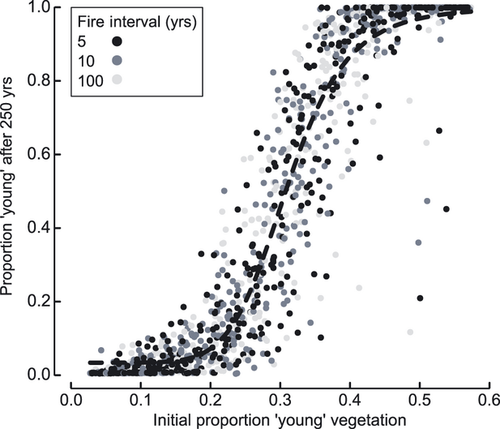
Running the model for 250 years while varying the initial amount of flammable vegetation confirmed a strong relationship between the initial amount of flammable vegetation and that present at the end of a model simulation (Fig. 2). Once the initial cover of young vegetation in the landscape exceeded approximately 40% – a value near the critical percolation threshold in the eight-cell (Moore) neighbourhood that we use for fire spread (Stauffer & Aharony, 1992) – then the probability was high that the landscape would shift to an almost entirely deforested state. This threshold dynamic is inherent in the moisture model hazard function (1) and suggests that, in the New Zealand context, transformation from forest to grassland/shrubland may have become progressively easier and hence more rapid as the landscape became more open.
Landscape dynamics under prehuman fire regimes
Running the model for 2500 years with fire intervals of 100, 250, 500, 750 and 1000 years (spanning the range of frequencies plausible for the prehuman Holocene in New Zealand – Ogden et al., 1998) consistently failed to result in significant deforestation. The maximum proportion of vegetation younger than 100 years after 2500 years in any single simulation was 8.1 × 10⁻⁴, with more than 60% of all simulations having no young vegetation present at their conclusion. In short, it is extremely unlikely that deforestation could have occurred in the absence of anthropogenic burning.
The nature of the fire regime during the Initial Burning Period
No targeting
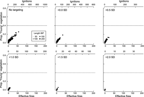
Under a scenario of spatio-temporally random ignition with 5% of the initial landscape in young vegetation, no realizations crossed the 40% young vegetation threshold (Fig. 3). Starting with landscapes composed of 10% young vegetation resulted in only a very few (2 of 400; 0.5%) realizations crossing the 40% young vegetation threshold, and both of those had an Initial Burning Period of 200 years duration (results not shown). Under random ignition, most ignition events did not result in sizeable fires; only 60% of ignition events spread beyond the cell in which ignition occurred and just 15% spread beyond the cells immediately neighbouring the ignition location.
Time targeting
Perhaps counter-intuitively, less deforestation occurred when ignitions were temporally targeted to occur in favourable years than when ignitions were spatio-temporally random. This outcome likely occurs because the critical minimum number of ignitions required for deforestation is not achieved under a strategy of targeting ignitions solely in time. The 40% young vegetation threshold was not crossed in any simulation under any of the time-targeting scenarios (Fig. 3). Although time targeting did not appear to be an effective strategy, extrinsic climate conditions did affect the amount of area burned in a given year. Quantile regressions show that extrinsic climate conditions were influential in determining burned area in extremely dry years (there is a strong positive relationship between burned area and cF in the upper 5% of annual burned area values), and this effect was amplified as the amount of young vegetation in the landscape increased (Figure SM 2.1; Spearman's ρ = 0.46 between extrinsic conditions and annual burned area for this particular model realization).
Space targeting
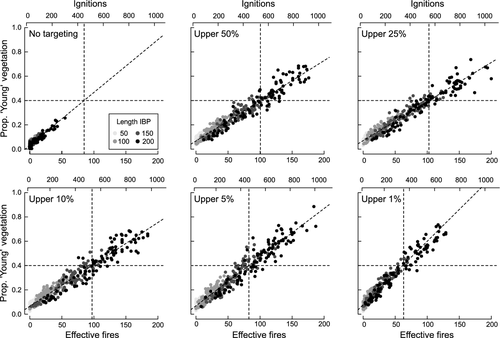
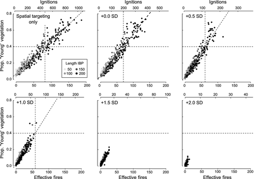
Targeting ignitions in space so that they only occurred in more flammable vegetation had a dramatic effect on the rate of deforestation (Fig. 4), with many more fires spreading beyond the immediate ignition location. In all spatial targeting scenarios, some simulations resulted in more than 40% young vegetation in the landscape, with an Initial Burning Period of 150–200 years required for the 40% threshold to be crossed consistently. In all spatial targetting scenarios with a 200-year-long Initial Burning Period, the median amount of young vegetation exceeded 40% (Fig. 4). The number of fires burning more than 1% of total landscape area (‘effective fires’) required to achieve 40% forest loss decreased with the precision of targeting. The effects of spatial targeting (relative to random ignition locations) were amplified if the initial abundance of young vegetation in the landscape was increased to 10%, and Initial Burning Period lengths of 100 years were sufficient to cross the 40% young vegetation threshold in some scenarios (results not shown).
Space and time targeting
Concurrent targeting in space and time, such that flammable vegetation was selected for ignition but only during those years in which climatic conditions were favourable for fire, required fewer ignitions and fewer effective fires to achieve significant deforestation than did either spatial or temporal targeting alone (Fig. 5). For example, when the upper 5% of flammable vegetation was targeted and fires were ignited only in years where extrinsic climate conditions (cF) were 0.5 SD above average, approximately the same extent of forest loss occurred as under a spatial-only targeting strategy, but with 25–50% fewer ignition events. The first of these scenarios (time and space) required only 110 ignition events (55 effective fires) to drive significant deforestation, whereas the second (space only) required 420 ignition events (90 effective fires). However, under scenarios where ignitions occurred only in very favourable years, forest loss declined as the number of ignitions fell (Fig. 5; cf. Fig. 3).
The role of fire in landscape maintenance after the Initial Burning Period
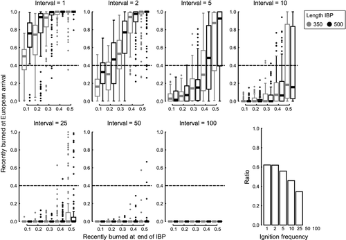
To maintain 40–50% of the post-Initial Burning Period landscape in shrubland/grassland required ignition frequencies of less than a decade; an average of 5 years between ignitions, coupled with ignitions spatially targetted was sufficient to maintain a deforested landscape (Fig. 6). Under 5- and 10-year ignition intervals, approximately 20–35% of ignitions translated into fires that burned more than 1% of the landscape, a result which suggests that maintenance of a deforested landscape required large fire events approximately every 15–35 years.
Discussion
The dramatic fire-driven deforestation that occurred in New Zealand following human settlement was repeated in islands and archipelagos across eastern Polynesia (Rolett & Diamond, 2004; Kirch, 2005) and is ongoing in many contemporary tropical and temperate biomass-rich wet forest systems (Cochrane, 2003). Thus, understanding how a small human population could effect such rapid and widespread transformation is of broad significance. The changes in fire regime and landscape composition that occurred in New Zealand at the time of Māori settlement are well known. Perry et al. (2012) argue that New Zealand's landscapes were highly susceptible to fire in prehuman times but that an ignition source was lacking (see also Ogden et al., 1998), and so the addition of ignition by Māori made widespread forest loss inevitable. Nevertheless, how a relatively small population transformed large areas in such a short interval remains less clear. The critical requirement seems to have been spatially targeting ignitions on the most flammable vegetation. To our surprise, the results suggest that simply targeting ignitions for the most favourable weather conditions was less effective and may have even hindered deforestation, possibly because it reduced the number of ignition events below some critical threshold.
The transformation of large areas of wet forest to seral grassland and scrubland was facilitated by the nature of the fire-hazard function in New Zealand fuels in which early successional scrubland is much more flammable than later successional forest. As with similar wet-forest systems, positive feedback loops between fire and vegetation, coupled with conducive climate conditions at broad-scales and changes in soil conditions, likely facilitated deforestation and may have even increased its rate over time. Most classical (e.g. negative exponential or Weibull) fire-hazard functions assume that flammability is either constant or increasing with time since fire; in fact, Johnson & Gutsell (1994, p. 250) state that assuming a decreasing hazard with age is simply not reasonable. While this assumption may be true of ecosystems where fire hazard is controlled by biomass accumulation, it is not the case where successional shifts in vegetation composition drive flammability, as in New Zealand. The hump-backed moisture hazard function (McCarthy et al., 2001) is an appropriate descriptor for systems where wet forest is replaced by grassland and/or shrubland after fire before slowly reverting back to wet forest. Few studies have considered the dynamics of ecosystems where flammability declines with time. Implicit in such systems is the potential for positive feedbacks in which changes in fire frequency may result in either more (if frequency increases) or less (if frequency declines) young, and hence more flammable vegetation. The paleoecological record suggests that human expansion across eastern Polynesia during the late Holocene was associated with a shift from relatively low flammability forest to higher flammability shrubland (e.g. Rolett & Diamond, 2004; Kennett et al., 2006; McWethy et al., 2009, 2010). Our modelling shows that even if human population densities were low, as in the South Island of New Zealand, achieving this transition may have been surprisingly easy. In short, ecosystems in which flammability declines with stand age are vulnerable to dramatic, and potentially rapid, changes in composition (e.g. from forest to shrubland) should fire frequencies change (see also Kitzberger et al., 2012).
Inherent in ecosystems where flammability decreases with time is a positive feedback in which fire begets fire – as more of the landscape burns, average flammability across the landscape increases, and so, in turn, average fire size increases and more of the landscape burns (Cochrane et al., 1999; Perry & Enright, 2002a). In New Zealand, this feedback process may have been amplified after initial deforestation by factors that slow succession, such as soil loss (McWethy et al., 2010) and reduced pollination and seed dispersal as bird populations declined during and after the Initial Burning Period (Clout & Hay, 1989; Kelly et al., 2010). Reducing forest cover may have been difficult initially but as landscape composition changed, transformation likely became progressively easier. Thus, the question of interest is not how did Māori transform 40% of the landscape, but rather how did they manage to burn sufficient forest for the positive feedbacks linking vegetation and fire to come into play.
Our results suggest that strategies focused on igniting fires in areas of the most flammable vegetation were required to drive large-scale forest loss. In shrubland-to-forest successions in New Caledonia, Perry & Enright (2007) found that the size of individual fire events could be predicted on the basis of the flammability of the ignition location and its immediate surroundings – in other words, the spatial context of ignition was important. Interestingly, Parisien et al. (2011) found that spatial patterns of ignition did not influence the spatial pattern of burn probabilities in landscapes in the boreal forest where fire regimes are largely free of human influence, but they note that ignition is likely to be an important driver of burn patterns in settings where ignitions are largely anthropogenic in origin. If targeted ignition strategies were adopted by early Māori, forest loss would have been rapid, with 40% forest loss realized in an Initial Burning Period as short as 100–150 years and with fewer than 100 large fire events (Fig. 5). This time span of initial burning is consistent with the evidence provided by well-dated high-resolution pollen and charcoal records from New Zealand (Wilmshurst, 1997; McWethy et al., 2010).
Of course, motivation for Māori burning is not directly testable using either field or model-derived data, although the ethnographic record provides some clues (Williams, 2009). The careful use of fire in space and time has been documented for other indigenous peoples (e.g. Allen, 2008; Bird et al., 2008), and there is every reason to believe that Māori were also savvy in their use of fire. At one level, the transformation that occurred in New Zealand was almost certainly premotivated. Kirch (1994) argues that Polynesians settling the archipelagos of eastern Polynesia transported a cultural landscape with them, and the clearance of forest by fire was a key component of achieving this remembered condition and making land available for horticulture. New Zealand was just one of many island groups that experienced an Initial Burning Period (Rolett & Diamond, 2004). It is, perhaps, more difficult to deduce what might have motivated early Māori to deforest so widely, especially given the limited evidence for prolonged or permanent settlement in many areas where such loss occurred. Central to the positive feedback dynamic that we describe, is the possibility that even if initial burning was localized (e.g. clearance for horticulture or ease of travel), widespread forest loss was inevitable, whether a desired outcome or not. The spatial decoupling between the patterns of forest loss and human activity in the New Zealand landscape during the prehistoric period (Perry et al., 2012) suggests that the introduction of an ignition source, independent of any deliberate fire use, into landscapes susceptible to fire (on the basis of climate and topography) was likely sufficient to trigger massive deforestation.
McWethy et al. (2010) argue that climate was not an important factor in driving landscape transformation during the Initial Burning Period, in as much as Initial Burning Period fires were asynchronous across the South Island and not confined to times of particularly warm or dry conditions as inferred from independent paleoclimatic data. On the other hand, once sufficient vegetation was vulnerable to fire, favourable climatic conditions may have acted to further amplify the fire-vegetation positive feedback. In temperate wet forests in South America, similar to those in New Zealand, interannual climate variability, such as the ENSO and SAM, are key controls on wildfire activity (Kitzberger et al., 1997; Holz & Veblen, 2011; Veblen et al., 2011). In contrast, we found that focusing fire activity in favourable years was insufficient in itself to deforest New Zealand's landscapes. In short, a minimum number of ignition events is required for landscape transformation to occur, and the outcomes of our simulated ignition scenarios suggest that vegetation exerts a stronger control on fire dynamics than interannual climate variability in landscapes best described by the moisture model hazard function.
Macroscopic charcoal levels are low in sediment-charcoal records following the Initial Burning Period (McWethy et al., 2009, 2010). This is likely due to a shift in the nature of the fires that accompanied the transformation from forest to shrubland/grassland, rather than a cessation of burning altogether. A shift to low-intensity surface fires in shrubland/grassland vegetation would have resulted in lower rates of macroscopic charcoal production. Many pollen diagrams from regions of New Zealand that were burnt following initial human settlement show persistent low levels of microscopic charcoal particles (<125 microns in diameter) in post-IBP sediments, coinciding with the abundant pollen of seral taxa and spores of bracken (McGlone & Wilmshurst, 1999). Without recurrent burning, the inferred grassland/shrubland communities would have been replaced by forest taxa in <100 years, according to our hazard function. Detailed pollen analyses showing vegetation responses to prehuman natural fire disturbances also show a rapid recovery following fire (Wilmshurst et al., 1997); even after large fires associated with the Taupo eruption, bracken and seral taxa were replaced by tall forest within 100–150 years in most North Island sites (Wilmshurst & McGlone, 1996). McGlone et al. (2005) suggest that recurrent use of fire (3–5 year intervals) by Māori, although likely at a lower intensity than required to clear forest, was required for the persistence of seral taxa, such as bracken. Our results suggest ignition frequencies of no more than 5–10 years, equating to a significant fire event perhaps every 15–35 years, and strategically placed ignitions were necessary to maintain seral communities for several centuries after the Initial Burning Period (Fig. 6).
Prehuman New Zealand was globally unusual in harbouring drought-adapted woody ecosystems intolerant of fire (McGlone, 2001). Once humans added fire to these ecosystems, hysteresis effects (sensu Scheffer et al. 2001) dramatically reshaped fire regimes. Following the Initial Burning Period, fire frequencies likely dropped, although remained higher than in prehuman NZ. Our simulations suggest that once Māori achieved initial forest loss, much reduced fire frequencies (15–35 years recurrence for significant fire events) would have maintained shrubland landscapes. A second wave of fire following European settelement precipitated more clearance, such that 70–80% of NZ forest cover has been lost in the last 700 years (Ewers et al., 2006).
The positive feedback mechanism that we outline has dramatically increased the susceptibility of the present landscape to fire, and changes concurrent with increases in fire frequency have resulted in a rescaling of the fire-vegetation hazard function. The introduction of exotic pyrophyllic species (e.g. Pinus spp., Ulex europaeus [gorse], Hakea spp.) during the European period has increased the absolute flammability of the most flammable parts of the landscape and also altered postfire successional pathways (Sullivan et al., 2007). Simultaneously, the loss of soil cover (Ogden et al., 2006) and key bird pollinators and seed dispersers (Kelly et al., 2010; Anderson et al., 2011) has slowed the rate at which communities currently move through the critical high flammability window. What we are left with is ‘ecosystems in waiting’ (McGlone, 2001); this is the case for many islands across the eastern Polynesia that experienced similarly dramatic rescalings of the fire regime (Kirch, 2005), soil erosion and a dramatic loss of avifauna. How future climate change will affect these dynamics is uncertain, but the key to restoring New Zealand's wet forest landscapes is the exclusion of fire and any process that acts to increase fire frequency (or intensity).
A primary strength of ours and any simulation model is its use as a heuristic device for experimentation and hypothesis testing. Our model is deliberately simple and place-neutral. It represents a first step in using simulation modelling to improve our understanding of ecological change during the early period of Māori settlement in New Zealand and so by extension elsewhere in eastern Polynesia in the late Holocene and in contemporary wet forests experiencing fire-driven transformation. These simulations might usefully be extended by: (i) using a more field-grounded parameterization of the moisture hazard function, (ii) including more data-driven representations of annual/decadal climate variability, and (iii) more explicit representation of the decision-making process as it relates to Māori use of fire (e.g. via an agent-based approach). Development of the model in these directions will allow the use of the model and paleoenvironment data more iteratively. Using the model to explore the fire response of specific landscapes in a manner that is directly testable with palaeodata would also be fruitful. For example, the model might be used to explore the fire history of particular landscapes, e.g. those that might have been especially vulnerable to fire because of their location (Perry et al., 2012), or be integrated with paleoclimatic reconstructions to examine at the consequences of interannual or interdecadal climate variability of fire activity.
Acknowledgements
David O'Sullivan provided technical advice on model implementation. Tom Veblen, Andres Holz and Juan Paritisis provided useful discussion on parallels with South American ecosystems. Three anonymous referees provided constructive criticisms that helped to improve the manuscript. This research was funded by the New Zealand Foundation for Research, Science and Technology in the Ecosystem Resilience Outcome Based Investment programme to JW, MM and GP and the Royal Society of New Zealand Marsden Fund to MM, JW, GP and CW and by grants from the US National Science Foundation (OISE 0966472, BCS 1024413) to CW and DM.


