Urbanization Pressures on Climate Adaptation Capacity of Forest Habitats
Funding: This study was supported by the Natural Science Foundation of China (#42261144754 and #42405119).
ABSTRACT
Urbanization extensively shapes the wildland–urban interfaces (WUIs). However, the effects of urbanization on forest habitats in WUIs as thermal refuges for biodiversity remain elusive. Here, we show that urbanization-induced increases in human footprints cause canopy degradation of forest habitats in WUIs, including declines in forest coverage (−12.61% ± 0.05%), leaf area index (−0.45 ± 0.01 m2 m−2), and canopy height (−3.74 ± 0.02 m). Canopy degradation weakens forest-based climate change adaptation, inferred by reduced forest habitat connectivity (−9.45% ± 0.08%) and elevated daily mean surface temperature (0.41°C ± 0.01°C) in WUIs, leading to a rise in frequency (0.22 ± 0.01 days) and intensity (1.05°C ± 0.02°C) of annual mean thermal extremes compared to that in nearby wildlands. A 10.01% ± 0.07% lower mean species richness in WUIs than nearby wildlands demonstrates local biodiversity loss in WUIs driven by intense human footprints, declined habitat connectivity, and increased thermal stress. We highlight the need for urban planning to fully integrate solutions for climate adaptation and biodiversity conservation.
1 Introduction
Approximately one-third of the land surface is forested, making these areas the most important global repositories of terrestrial biodiversity (Hansen et al. 2013; Liang et al. 2016). Natural and seminatural forests are often regarded as thermal refuges for biodiversity against climate change (Sgrò et al. 2011; Watson et al. 2018). Forests not only mitigate global warming by capturing and storing carbon from the atmosphere into ecosystems but also buffer local microclimates by evapotranspiration and shade effect (Jiao et al. 2024; Paschalis et al. 2021), thereby providing a relatively stable thermal environment for species. Furthermore, forest habitats with high connectivity augment the success rate of species in their migration toward suitable thermal habitats against climate warming (Nuñez et al. 2013).
Urbanization accelerates the loss and degradation of forest habitats worldwide (Curtis et al. 2018). Urbanization expands impervious surfaces, irreversibly modifying and replacing forest landscapes. The expanding impervious surfaces enhance the absorption of solar radiation and reduce evapotranspiration, leading to warming in urban areas relative to rural areas, referred to as the urban heat island effect (Li et al. 2013; Wang, Chen, et al. 2021). As urbanization increases, the thermal stress spreads beyond urban boundaries due to the spillover of extra warmth from the urban heat island and anthropogenic heat release, exposing forest habitats in wildlands to warmer thermal environments (de Pauw et al. 2023; Zhang et al. 2009). Urbanization also affects natural areas beyond urban boundaries through broader human footprints. To meet urban development needs, human footprints such as farmland expansion and infrastructure construction are widespread in wildlands surrounding urban areas. Increased human footprints result in an unstable microclimate and fragmentation of forest habitats, which allows native species to live in warmer and isolated habitats, thereby threatening biodiversity in forest habitats (Engert et al. 2024; Zeng et al. 2018).
The most acute conflicts between urbanization and forest habitats occur in the wildland–urban interfaces (WUIs), defined as areas where human developments meet or intermingle with undeveloped wildlands (Radeloff et al. 2005; Schug et al. 2023). The WUIs attract residents due to their accessibility to ecosystem services and socioeconomic benefits provided by nature, rendering them desirable places to live for many (Ager et al. 2019). Meanwhile, WUIs contain abundant natural vegetation, especially forests, offering habitats for periurban species. However, urbanization globally is driving an unprecedented expansion of the WUIs in the twenty-first century, and the escalating human activities in WUIs present increasing threats to natural systems (Jenerette et al. 2022). Urban expansion has resulted in increased risks of human-ignited fires (Guo et al. 2024), light and noise pollution (Aguilera and González 2023), and introductions of invasive species in WUIs (Borden and Flory 2021). House growth in WUIs provides more targets for embers from burning vegetation, increasing wildfire spread and intensity (Koo et al. 2010). Noise and light pollution from residential activities, combined with introductions of pets as potential non-native predators, pose great threats to local biodiversity in WUIs (Radeloff et al. 2023). However, a major knowledge gap remains on changes in wildlife thermal habitat and canopy connectivity along WUI under urbanization.
Given the critical role of forest habitats in maintaining biodiversity, it is not fully understood to what extent urbanization exerts human pressure on forest habitats in WUIs, and how urbanization affects the capacity of forest habitats providing thermal refuges for biodiversity against climate change. Here, we use multisource satellite observations of human footprints and forest canopy parameters to investigate the impacts of human footprints related to urban expansion on forest habitats. Human footprints increase as urbanization proceeds, which degrades forest habitats through reducing forest coverage and increasing forest fragmentation (Mitchell and Devisscher 2022). As the habitat connectivity and thermal environment are modified with the increased human footprints, the local biodiversity is expected to be affected (Krosby et al. 2010). Therefore, we further assess the joint effect of declined habitat connectivity and increased thermal stress on local biodiversity measured by the mean species abundance metric in WUIs.
2 Materials and Methods
2.1 Identification of Forest Habitats in the Wildland–Urban Interfaces
Global forest cover and height data at 30-m resolution of 2020 was obtained from the Global Land Analysis and Discovery (GLAD) Global Land Cover and Land Use Change dataset (Potapov 2022). The forest cover data define a pixel with a tree height of greater than 5 m at the Landsat pixel scale as a forest pixel, aligning with the definition of forest by the Food and Agriculture Organization of the United Nations. We aggregated forest cover data into forest cover fraction data at 0.01° resolution. Global WUI data are based on the WUI definition published by the US government in the Federal Register and integrates multiple data points including building footprint (Chen et al. 2024; Chen 2024). We obtained the WUI data at 300-m resolution of 2020 and further aggregated the data into WUI fraction at 0.01° resolution. Forest habitats in WUIs was identified as pixels with forest cover fraction greater than 60% and WUI cover fraction greater than 60%. Meanwhile, forest habitats in wildlands were identified as pixels with forest cover fraction greater than 60% and WUI cover fraction equal to zero.
2.2 Human Footprint Change in the Wildland–Urban Interfaces
The human footprint is a composite measure of eight variables reflecting different human pressures, including the built environment, population density, nighttime lights, cropland, pasture, roads, railways, and navigable waterways (Mu et al. 2022). The human footprint values range from 0 (no human impact) to 50 (the highest human impact). We normalized the human footprint by multiplying by a factor of 0.02 to convert the value into a human footprint intensity percentage based on the map of global human footprints at 0.01° resolution in 2020 (Mu et al. 2021).
In addition, we calculated the ΔHFP of the three forest habitats, including boreal, temperate, and tropical forest habitats. Boreal forests are located within 50° N to 70° N, temperate forests within 25° N to 50° N, and tropical forests within 25° S to 25° N. We also calculated ΔHFP of countries with different levels of human development. We used the Human Development Index (HDI) of the United Nations Development Programme in 2020 to divide world countries into “higher” human development level (HDI ≥ 0.7) including high to very high human development level, and “lower” human development level (HDI < 0.7) including medium-to-low human development level (Sagar and Najam 1998; UNDP 2022). In general, countries with lower human development level are mainly located in the tropical regions, while countries with higher human development level are mainly located in the temperate and boreal regions (Figure S1).
2.3 Forest Canopy Degradation in the Wildland–Urban Interfaces
We chose forest cover, leaf area index, and canopy height as the key biogeophysical attributes of forest canopy. We aggregated 500 m MODIS 8-day leaf area index data (MOD15A2H) collected between 2016 and 2020 into annual mean leaf area index data at 0.01° resolution (Myneni et al. 2015). We aggregated the 30 m Global Land Analysis and Discovery forest height data in 2020 into 0.01° resolution (Potapov et al. 2021). The impact of urbanization and related human activities on forest canopy in WUIs was calculated as the differences of forest cover (ΔFC), leaf area index (ΔLAI), and canopy height (ΔCH) between WUIs and wildlands in the same 0.25° window, which is similar to the calculation method of ΔHFP in Equation (1). Negative values of ΔFC, ΔLAI, and ΔCH indicate forest canopy degradation in WUIs compared to wildlands.
2.4 Habitat Connectivity Change of Forest in the Wildland–Urban Interfaces
The impact of urbanization and related human activities on forest habitat connectivity in WUIs was calculated as the differences of forest habitat connectivity (ΔHC) between WUIs and wildlands in the same 0.25° window, which is similar to the calculation method of ΔHFP in Equation (1). Negative ΔHC values indicate forest habitats are more isolated in WUIs compared to wildlands. We assessed the impact of urbanization on forest habitat connectivity across varying maximum dispersal distances (4σ) ranging from 1 to 100 km (Figure S2). The ΔHC decreases as maximum dispersal distance (4σ) values increase. Therefore, urbanization has a greater impact on species with shorter maximum dispersal distances. Given the variability in dispersal distances among species, we set 4σ value to 10 km, representing the median maximum dispersal distance.
2.5 Biogeophysical Effect of Urbanization on Forest Surface Temperature
We further chose six explanatory variables including burned area (BA), urban intensity, road density, population density, 2 m temperature, and precipitation to represent human and climate factors affecting forest habitats through urbanization (Zhang et al. 2022). We derived annual mean burned area between 2016 and 2020 from the 0.25° ESA-CCI fire grid product (Fire_cci v5.1) (Chuvieco et al. 2012). We quantified urban intensity as the fraction of urban area in a 0.25° windows by annual maps of Global Artificial Impervious Area (GAIA) (Gong et al. 2020; Gong 2020). The road density and population density data are from the Global Roads Inventory Project dataset (Meijer 2018) and the Gridded Population of the World dataset (CIESIN 2017), respectively, and are aggregated to a 0.25° resolution. In addition, we calculated the annual mean precipitation and 2 m temperature from 2016 to 2020 based on the ERA5 reanalysis dataset (Hersbach et al. 2023). We used the Ordinary Least Squares (OLS) model to calculate the partial correlation coefficients of these explanatory variables with surface temperature difference and habitat connectivity difference. To ensure the robustness of the results, we ran the OLS models by randomly subsampling 30% samples with replacement out of the entire data 500 times and calculated the mean partial correlation coefficient for each explanatory variable across all model runs. Additionally, we calculated the Moran's I values for the residuals estimated by the OLS models, which were 0.003 for the boreal region, 0.010 for the temperate region, and 0.002 for the tropical region. All these values are close to zero, indicating that there is no significant spatial autocorrelation in the residuals.
2.6 Effect of Urbanization on Local Biodiversity
3 Results
3.1 Forest Canopy Degradation in WUIs
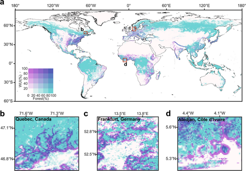
As urbanization proceeds, urban boundaries continue to grow, thereby expanding the WUIs between urban areas and wildlands (Figure 1). Forest habitats in WUIs experience greater human pressures than those in wildlands, especially in the highly urbanized regions, that is, North America, Europe, and East Asia (Figure 2a). Global forest habitats in WUIs experienced human footprint intensity of 37.12% ± 0.11% (mean ± standard error) in 2020, which was much higher (ΔHFP = 13.22% ± 0.03%) than forest habitats in nearby wildlands. Due to the high human footprints, forest habitats in WUIs showed substantial canopy degradation. More than 82%, 84%, and 90% of forest habitats in WUIs experienced declines of forest cover (ΔFC = −12.61% ± 0.05%), leaf area index (ΔLAI = −0.45 ± 0.01 m2 m−2) and canopy height (ΔCH = −3.74 ± 0.02 m), respectively, compared to nearby forest habitats in wildlands in 2020 (Figures S3–S5). Increased human footprint intensity significantly accelerates degradation of forest canopy in WUIs (Figure 2b–d). Global mean declines of forest cover, leaf area index, and canopy height in WUIs increase significantly as ΔHFP increases.
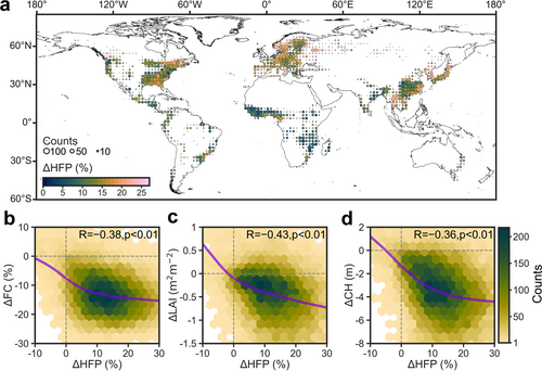
The human footprint pressure on WUIs in countries with higher human development level (ΔHFP = 14.56% ± 0.08%) is higher than that in countries with lower human development level (ΔHFP = 8.18% ± 0.12%). The greater human pressures on forest habitats in countries with higher human development level drive greater declines of forest cover (ΔFC = −12.85% ± 0.05%), leaf area (ΔLAI = −0.50 ± 0.01 m2 m−2) and canopy height (ΔCH = −3.75 ± 0.27 m) than those in countries with lower human development level (ΔFC = −11.70% ± 0.12%, ΔLAI = −0.29 ± 0.01 m2 m−2 and ΔCH = −3.66 ± 0.67 m).
3.2 Connectivity Loss of Forest Habitats in WUIs
Continued degradation of forest canopies causes forest fragmentation in WUIs, which can be inferred by declined landscape connectivity (ΔLC < 0%) in forest habitats. In addition, human footprints act as physical barriers to landscape connectivity because animals tend to avoid migrating to habitats with intense human activities. Here, we defined habitat connectivity as the connectivity influenced by landscape fragmentation and human footprints, which is more comprehensive than landscape connectivity influenced only by fragmentation. Global mean forest habitat connectivity in WUIs is 49.02% ± 0.15% in 2020 with the lowest mean value in the temperate regions of 46.5% ± 0.12% (Figure 3a), which is nearly 30% lower than the global mean landscape connectivity (71.42% ± 0.18%) (Figure S6). Nearly 85% of forest habitats in WUIs show lower habitat connectivity (ΔHC = −9.45% ± 0.08%) than those in nearby wildlands (Figure 3b). The habitat connectivity decline is the greatest in the boreal (ΔHC = −12.03% ± 0.19%), followed by the temperate (ΔHC = −9.46% ± 0.11%) and tropical (ΔHC = −8.47% ± 0.14%) regions. This is because developed cities are more concentrated in the temperate and boreal regions, where the impact of human footprints on wildlands is more pronounced, thereby exacerbating the loss of habitat connectivity compared to that in the tropical regions (Figure 2a).
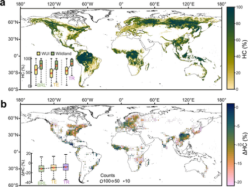
Forest landscape connectivity decline in WUIs in countries with higher human development level (ΔLC = −6.72% ± 0.06%) is slightly lower than that in countries with lower human development level (ΔLC = −7.27% ± 0.11%). However, countries with higher human development level have a higher human footprint intensity, creating stronger physical barriers. As a result, forest habitat connectivity decline in WUIs in countries with higher human development level (ΔHC = −9.60% ± 0.08%) is higher than that in countries with lower human development level (ΔHC = −8.89% ± 0.11%).
3.3 Declined Climate Change Adaptation for Biodiversity in WUIs
Degradation of forest canopy and forest fragmentation in WUIs further influences the thermal environment of forest habitats. Surface temperature in more than 86% of the forest habitats in WUIs is higher (ΔST = 0.41°C ± 0.01°C) than in nearby wildlands due to the declined cooling effect of forest in WUIs (Figure 4a). This declined cooling effect is higher in the tropical WUIs (0.48°C ± 0.02°C) than in the temperate (0.43°C ± 0.02°C) and boreal (0.16°C ± 0.01°C) WUIs. The more severe the degradation of forest canopy, the greater the decline in the cooling effect of the forest in WUIs (Figure 4b–d), indicating that human footprints caused by urbanization deteriorate the thermal environment of forest habitats in WUIs by degrading the forests (Figure 2b–d).
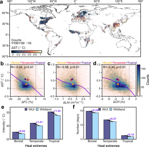
Forest habitats in WUIs experience increased annual mean frequency (0.22 ± 0.01 days) and intensity (1.05°C ± 0.02°C) of heat extremes than that in wildlands, especially in the tropics where annual mean intensity and frequency of heat extremes are 1.34°C ± 0.03°C and 0.27 ± 0.01 days higher than that in wildlands, respectively (Figure 4e,f and Figure S7). Furthermore, the surface temperature difference in countries with lower human development level (0.43°C ± 0.02°C) is higher than that in countries with higher human development level (0.33°C ± 0.01°C).
More than 65% of forest habitats in WUIs experience both surface temperature increase (ΔST > 0 °C) and habitat connectivity decline (ΔHC < 0%), indicating reduced benefits of forest habitats in WUIs to provide connected thermal refuges for animals against climate warming (Figure S8a). Notably, these degraded forest habitats in WUIs have different combination patterns of surface temperature increase and connectivity loss, suggesting that the main threats to biodiversity in these habitats are different, and these patterns of habitat connectivity difference and surface temperature difference mainly depend on human population density and background climate (Figure S8b). Especially, approximately 35% of these degraded forest habitats are experiencing relatively low connectivity loss (ΔHCmedian = −11.97% and ΔHC > ΔHCmedian) but high surface warming (ΔSTmedian = 0.23°C and ΔST > ΔSTmedian), especially in the tropical forests, where humid climate exacerbates surface temperature difference. Approximately 20% of these degraded forest habitats are experiencing relatively high connectivity loss (ΔHC < ΔHCmedian) and high surface warming (ΔST > ΔSTmedian), especially in temperate Europe and East Asia. In these regions, the relatively high population density and urban intensity contribute to the relatively high connectivity loss, and the relatively humid climate exacerbates surface temperature difference.
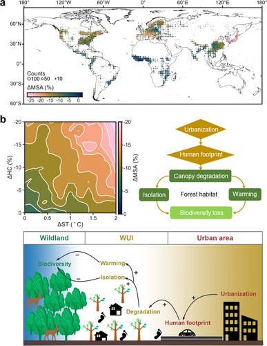
Degradation patterns of thermal buffer and connectivity of forest habitats in WUIs diminish local biodiversity. Currently, the global mean species abundance is 65.12% ± 0.3%, which approximately doubles the mean species abundance of forest habitats in WUIs (38.91% ± 0.2%). More than 86% of forest habitats in WUIs experience mean species abundance loss (ΔMSA = −10.01% ± 0.07%) compared to nearby forest habitat in wildlands (Figure 5a). The mean species abundance is higher in the boreal (81.77% ± 0.05%) than in the temperate (57.24% ± 0.03%) and tropical (52.69% ± 0.03%) forest habitats in wildlands. The loss of mean species abundance of forest habitats in the temperate (12.7% ± 0.37%) and boreal (11.34% ± 0.18%) WUIs is more than double that of tropical WUIs (5.6% ± 0.25%), indicating higher vulnerability of biodiversity in the mid- and high-latitude WUIs. The loss of species abundance greatly depends on the extent of local warming and connectivity loss caused by canopy degradation (Figure 5b). For each 1% decrease in habitat connectivity, the mean species abundance of forest habitats in WUIs decreases by about 0.29%. While for each 1°C increase in habitat surface temperature, the mean species abundance in WUIs decreases by about 3.06%. With the urbanization process, the increased human footprints exacerbate forest canopy degradation in WUIs, resulting in local warming and habitat connectivity loss, thereby reducing the local biodiversity of forest habitats in WUIs (Figure 5b).
4 Discussion
Urbanization not only affects landscape patterns within urban boundaries but also extends its impact beyond urban boundaries through extensive human footprints. Human footprint expansion accelerates ecosystem degradation, including the loss of biomass carbon (Geng et al. 2023), leaf area (Liu et al. 2024), and intact ecosystems (Williams et al. 2020). This study provides observational evidence that the rapid encroachment of human footprints into wildlands creates widespread WUIs worldwide, threatening the quality of forest habitats in wildlands. Unlike forests in urban areas under clear management strategies, sustainable forest management is often lacking in the transition zones between urban areas and wildlands (Schug et al. 2023). We show that the forest canopy in WUIs has been greatly degraded due to increased human footprint intensity.
Continued canopy degradation will eventually lead to forest loss, resulting in fragmentation of forest habitats. Here, we find that global forest habitats in WUIs become more isolated. The landscape connectivity of forest habitats, which governs the movement of animals and their genetic exchange among forest habitats, plays a pivotal role in the migratory success of animals in response to current and future climate change (Cadavid-Florez et al. 2020). Therefore, the loss of forest landscape connectivity caused by urbanization reduces the ability of native species to adapt to climate change, thereby threatening biodiversity in the urban-nature ecosystem (Littlefield et al. 2019). During urban development, it is necessary to plan connected ecological corridors in WUIs between cities and wildlands to help animals in urban ecosystems migrate in response to climate change and urban heat stress.
Urbanization in countries with lower human development levels leads to more severe loss of landscape connectivity of forest habitats than in countries with higher human development levels. This is because in the lower development countries, settlement in wildlands is more random and less planned to preserve the integrity of forest habitat landscape, thereby exacerbating the landscape fragmentation (Hansen et al. 2020). However, urbanization in countries with higher human development levels leads to more severe loss of habitat connectivity than in countries with lower human development levels when considering human footprint. Urbanization in countries with higher human development levels tends to affect broader regions, resulting in high-intensity human footprints spreading into remote wilderness areas. While in countries with lower development levels, urbanization is still concentrated and compact, with human footprints largely confined to cities and their surrounding rural areas (Seto et al. 2012). Habitats with higher human footprints tend to experience more stress from human disturbances, such as infrastructure construction and reclamation. Even if these habitats meet the requirements for animal survival in terms of landscape connectivity, animals will still bypass these areas of high human footprints (Cao et al. 2020). Therefore, given the higher human footprints in countries with higher human development levels, habitats in these countries actually experience greater connectivity loss than those in countries with lower human development levels, highlighting the dual impacts of the human footprints on animal migration between forest habitats through altering landscape morphology and acting as a physical barrier. We emphasize the importance of incorporating the human footprints into the quantification of habitat connectivity.
It is commonly believed that forests can mitigate climate warming as a nature-based solution (de Frenne et al. 2021). However, our results indicate that the thermal environment of forest habitats is destabilized due to urbanization. Urbanization causes increased human disturbance to forests in WUIs, leading to widespread canopy degradation, directly altering the thermal environment of forest habitats. The declines in forest cover, leaf area index, and canopy height result in reduced evapotranspiration, weakening the turbulent heat exchange between the forest and the atmosphere (Chen et al. 2020), thereby warming the surface. Moreover, the extra warmth from urban heat islands and anthropogenic heat in nearby urban areas is easily transported downwind to WUIs and affects thermal conditions there (Zhang et al. 2009).
Previous studies have shown that natural forests can provide animals with thermal refuges from climate change due to their ability to buffer microclimates and maintain high connectivity (Watson et al. 2018). As a transitional zone between natural ecosystems and human-dominated urban ecosystems, forest habitats in WUIs are close to the city and retain certain climate buffering capacity, which could constitute a potential destination for urban biodiversity transfer during urbanization (Maron et al. 2015; Sponagel et al. 2022). However, this study shows that urbanization is accelerating the loss of these thermal refuges. More than 65% of forest habitats in WUIs are facing connectivity loss and thermal stress, while over 86% are experiencing declines in mean species abundance. As human footprints increase, these habitats in WUIs tend to experience more severe warming and thermal extremes, which could be deadly for some animals if the temperature exceeds species' thermal limits (Araújo et al. 2011; Lawler et al. 2015). Even if some species can shift their niches and disperse beyond WUIs boundaries toward the interior of wildlands in response to warming, these species could still be at a high risk because low habitat connectivity due to urbanization and related human footprints does not support their migration (Román-Palacios and Wiens 2020).
The dominant processes by which urbanization affects local biodiversity vary among the tropical, temperate, and boreal forests. Dense tropical forest canopies promote turbulent heat exchange between the land and the atmosphere, creating cooler habitats for species in the hot climates (Zhu et al. 2023). However, human activities by rapid urbanization and population explosion in these regions have increased forest canopy degradation and intensified local thermal stress, which is more severe than that in the temperate and boreal regions. Considering that tropical species have evolved to adapt to narrow temperature ranges and are highly sensitive to temperature changes, biodiversity in tropical WUIs faces heightened thermal stress (Wright et al. 2009).
The boreal forests are characterised by relatively simple forest canopy structure with limited water and heat availability (Wang, Zhang, et al. 2021). Urbanization-induced canopy degradation exerts a low influence on the local thermal environment. However, the loss of forest habitat connectivity driven by human activities is more pronounced in the boreal regions. Species in these regions are more susceptible to losing their local movement opportunities compared to the tropical regions, resulting in high local extinction risks under climate warming (Powers et al. 2013). Furthermore, urbanization disrupts both the habitat connectivity and thermal environment of the temperate forests, underscoring the heightened threats to local biodiversity in the temperate regions.
Disturbances in thermal environments and connectivity of forest habitats caused by urbanization may affect biodiversity in distant areas. The boreal forests are often considered to be suitable thermal refuges for species living in lower latitudes to adapt to climate warming (McGuire et al. 2016). However, compared to forests in lower latitudes, the growth of boreal forests is limited by low temperatures and is less resistant to external disturbances (Reich et al. 2014). We find that urbanization causes higher landscape connectivity loss in the boreal forests than in the temperate forests. Therefore, under the influence of urbanization, it is difficult for animals experiencing thermal stress in the temperate regions to migrate poleward to reach thermal habitats with suitable temperatures.
Regional differences in human development levels may lead to quite divergent impacts of urbanization on forest habitats in WUIs. Most countries with lower development are located in tropical regions. Owing to limited financial resources, weak governance, and low public awareness, urbanization in these countries accelerates forest habitat loss, posing a direct threat to local climate stability (Lambin et al. 2014). Providing economic incentives in countries with lower human development levels is crucial for forest conservation in WUIs (Naime et al. 2020). For example, Costa Rica's government-led Payments for Ecosystem Services (PES) program successfully reversed forest loss and restored connectivity impacted by rapid urbanization (Daniels et al. 2010). Moreover, establishing stronger international partnerships is vital to combat forest degradation driven by urbanization. For example, Vietnam and Panama are restoring forests degraded by urbanization through the United Nations Reducing Emissions from Deforestation and forest Degradation in developing countries (REDD+) program (Sloan 2015).
Although adequate funding and effective governance promote efficient forest restoration in the temperate and boreal regions with a higher human development level, the expansion of dispersed settlements in peri-urban areas and the unregulated development of private properties (e.g., vacation homes) within wildlands further intensify forest fragmentation (Liu et al. 2019). In China, the reclamation of small and fragmented farmlands for fresh produce in suburban areas intensifies the loss of natural habitat connectivity (Wang 2024). In the United States, forest connectivity is intentionally reduced in WUIs to prevent private houses and forests from fires (Calkin et al. 2014). Therefore, land planning and management, for example, private forests, in peri-urban areas should be strengthened in countries with a higher human development level (Mostegl et al. 2019). Furthermore, solutions to balance urban development and biodiversity conservation need to be further explored in the WUIs. One potential solution is to establish ecological corridors between urban and wildlands to support species movements in the context of urbanization, which has been successfully implemented in many cities in China (Peng et al. 2017).
Although our results demonstrate how urbanization is reducing the climate adaptation capacity of forest habitats in the WUIs globally, several potential areas of hotspots require further exploration. Satellite-based analysis effectively captures the general patterns of urban impact on forest habitats. However, the influence of potential confounding factors at finer scales (e.g., forest type, urban morphology, and local topography) on thermal habitats and connectivity requires further investigation (Chen et al. 2022; Huang and Wang 2019). In addition to buffering local climate through biophysical effects, forests also modify the global macroclimate by regulating the carbon cycle (Zhu et al. 2023). The gap remains in the extent to which urbanization alters carbon sequestration of forests in the WUIs and thus affects the climate mitigation capacity of forests. Additionally, observational data for validating the impacts of changes in thermal environments and connectivity on local biodiversity is lacking.
To conclude, urban areas toward wildlands exacerbate human footprints on wildlands. With the urbanization process, the increased human footprints exacerbate forest canopy degradation in WUIs, driving a shift in these habitats toward more isolated and warmer conditions, thereby reducing the benefits of these habitats as thermal refuges for animals against climate warming. We highlight the need for urban planning to fully integrate climate solutions, biodiversity conservation, and socio-economic development needs.
Author Contributions
Anqi Huang: conceptualization, formal analysis, writing – original draft, writing – review and editing. Xiyan Xu: conceptualization, writing – original draft, writing – review and editing. Gensuo Jia: writing – original draft, writing – review and editing.
Conflicts of Interest
The authors declare no conflicts of interest.
Open Research
Data Availability Statement
The data that support the findings of this study are openly available Zenodo at https://doi.org/10.5281/zenodo.15065363. The global wildland–urban interface dataset was obtained from the University of Hong Kong (HKU) Data Repository at https://doi.org/10.25442/hku.24939606.v1. The Global Land Cover and Land Use Change dataset was obtained from Global Land Analysis and Discovery (GLAD) Laboratory at the University of Maryland at https://glad.umd.edu/dataset/GLCLUC2020 (version 2). MODIS Aqua land surface temperature (LST) (MYD11A2 Version 6) was obtained from NASA EOSDIS Land Processes Distributed Active Archive Center at https://doi.org/10.5067/MODIS/MYD11A2.006. MODIS leaf area index (LAI) dataset (MOD15A2H Version 6) was obtained from NASA EOSDIS Land Processes Distributed Active Archive Center at https://doi.org/10.5067/MODIS/MOD15A2H.006. Human development level (HDL) data was obtained from United Nations Development Programme (UNDP) at https://hdr.undp.org/data-center/human-development-index#/indicies/HDI. Global record of human footprint dataset was obtained from Figshare at https://doi.org/10.6084/m9.figshare.16571064 (version 7). Annual maps of global artificial impervious area (GAIA) were obtained from Peng Cheng Laboratory at https://data-starcloud.pcl.ac.cn/iearthdata (version 2024). The road density data was obtained from Zenodo at https://doi.org/10.5281/zenodo.6420961 (version 4-2018). The population data was obtained from NASA Socioeconomic Data and Applications Center at https://doi.org/10.7927/H49C6VHW. ERA5 reanalysis datasets were obtained from the Copernicus Climate Change Service (C3S) Climate Data Store (CDS) at https://doi.org/10.24381/cds.f17050d7. The global mean species abundance data was obtained from Global biodiversity model for policy support (GLOBIO4) at https://www.globio.info/globio-data-downloads (version 2015-Schipper et al.).


