Impact of human activities on the evolution of the Romanian Black Sea beaches
Abstract
The Romanian Black Sea coastal zone is divided into two main sectors. Sediment characteristics and general transport patterns are presented for each of them. The human activities influencing the beaches’ evolution are depicted and the present-day impact described.
INTRODUCTION
The Romanian Black Sea coastal zone spreads from the southern mouth of the Chilia Distributary in the north, to the Romanian–Bulgarian border (at the village of Vama Veche) in the south. It has a total length of 243 km and it can be divided into two sectors from both geological and geomorphological points of view ( Fig. 1). The boundary between the sectors is usually placed at Cape Midia. However, from a geological point of view, this boundary should be placed in the area where the Danube ceases to influence the coastal zone, that is, further southwards, to include Mamaia Bay. From a geomorphological point of view, the presence of cliffs north of Cape Midia shows that the boundary should be placed approximately 10 km north of its conventional position.
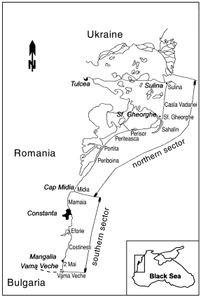
Romanian Black Sea area showing the main beach sectors.
In both sectors, the beaches’ evolution is determined by the existing relationship between the quantity of sediments that are available for transport and sedimentation and the sea energy, expressed in the coastal zone by marine waves and currents. Along the Romanian littoral zone, the main marine current that redistributes the sediments is oriented from north to south, parallel to the shoreline. Both sectors have their own specificity in regard to both the sediment supply and the sea’s energetic regime.
CHARACTERISTICS OF THE NORTHERN SECTOR
The northern sector is placed in front of the Danube Delta and its evolution is well correlated with that of the delta. From a geomorphological point of view, the littoral zone is a low area consisting of bars of arenitic sediments that either border the wetlands from the marine deltaic field, or separate former lagoons from the sea. From a sedimentary point of view, the main feature is the presence of important amounts of the arenitic fraction, consisting mainly of quartz, with local enrichments in heavy minerals. The volume of beach sediment that the carbonate fraction (shells and shell fragments) represents increases from north to south, from several percent at Sulina to more than 90% at Periboina. The main source of arenitic material is the Danube River, through its three distributaries. The compositional variation is therefore related to the distance to the river mouths.
CHARACTERISTICS OF THE SOUTHERN SECTOR
The southern sector is characterised by the presence of cliffs, interrupted in several zones (Mamaia, Eforie, Costinesti and North Mangalia) by littoral bars. The cliffs are both active and inactive. From a geomorphological point of view, the littoral bars are similar to those that border the lagoons in the northern sector. However, essential differences appear in the sedimentological characteristics of their constituents. The source of the sedimentary material is mainly carbonate and biogenous, which accounts for the preponderance of medium- and coarse-grained bioclasts (80–90%). The remaining sedimentary material is from the erosion of the cliffs, transport from offshore, dikes, groynes and breakwater erosion and also from artificial sand that has been added to the tourist beaches. The sediment grain size increases from north to south, with cobbles being present from Eforie to Vama Veche. The cliffs consist of a succession, with Sarmatian organogenic limestone at the bottom, covered by Villafranchian red clays, then, in the upper part, a succession of loess levels, separated by palaeosoils.
ANTHROPOGENIC INFLUENCE ON THE COASTAL ZONE
Human activities have altered both the quantity and quality of the sediments from the littoral zone and also the activity of the marine transport agents. These activities can be classified into the following groups: (i) hydrotechnical works along the Danube and its main tributaries; (ii) harbour protection and other coastal engineering works; (ii) introduction of opportunistic species to the Black Sea basin; and (iv) direct intervention on the backshore sediments.
Hydrotechnical works along the Danube and its main tributaries
The hydrotechnical works with the greatest influence are the dams built on the Danube (Portile de Fier I and II). They retain the sediments transported from upstream, creating a sedimentary deficit in the littoral zone. Thus, after the construction of the Portile de Fier I Dam in 1970, the total sediment discharge has diminished by approximately 30–40% ( Panin 1996). The sediment retention in the dam lakes is even higher, but the Danube partially compensates for the sedimentary deficit by eroding the riverbed ( Panin 1996).
The construction of dams on the Danube’s main Romanian tributaries has rendered their sediment loads insignificant. The rectification works that have been carried out on the Danube distributaries during the past 130 years have altered the distribution of liquid and solid discharges. As a result of all these changes, the sediment load brought by the Danube into the Black Sea littoral zone has been drastically reduced from approximately 65 × 106 t in 1858 to 38 × 106 t in 1988 ( Panin 1996; Giosan et al. 1997 ).
Harbour and other coastal engineering works
Engineering works in this category include: the jetties that protect the Sulina Navigation Canal; the protection jetties of the Midia; Constanta South and Mangalia harbours; and the littoral protection works (groynes and breakwaters) from the tourist beaches.
The two parallel jetties at Sulina, with a length of approximately 8 km, have modified the distribution of marine currents. The sediments transported by the Chilia Distributary and by the longshore current from the north cannot pass the harbour system and are either deposited in Musura Bay or redirected offshore. Moreover, the alluvia brought by the Sulina Distributary enter the littoral system a long distance from the shoreline. The presence of these jetties at Sulina induces the appearance of an anticyclonal current immediately south of the jetties ( Panin 1996; Giosan et al. 1997 ). The sedimentary deficit is even more intense because of the dredging of the Sulina bar and the dumping of this material approximately 4 km south-east of the end of the jetties.
The Midia, Constanta South and Mangalia Harbour jetties represent obstacles for the longshore current. The most important is the Midia Harbour jetty, which interrupts the southward transport of the Danubian sediment by the longshore current. Thus, these sediments are either deposited north of the harbour, or redirected offshore. Because of this, the entire southern sector of the Romanian littoral zone is almost completely deprived of Danubian sediments. Furthermore, these harbour jetties induce anticyclonal currents, thus altering sediment transport.
In tourist areas, coastal protection engineering works were built in order to halt the erosion. Unfortunately, as observed worldwide, this solution does not solve the problem, being only a local solution, as the erosion always migrates downdrift.
Introduction of opportunistic species in the Black Sea basin
The introduction (on the keels of ships) of opportunistic invertebrates that have had an explosive development in the Black Sea basin, have induced changes between the mineral and organogenic fractions of beach sediments. One such species is Mya arenaria, described for the first time in Romania in 1972 ( Gomoiu & Skolka 1996). Over time, massive accumulations of shells become an important source of sediments after their reworking by waves and currents.
Direct intervention on beach sediments
The direct intervention on beach sediments has mainly been the collection of the coarse organogenic fraction (shells and shell fragments) from the tourist beaches. This is only partially compensated by the artificial sediment nourishment.
BEACH RESPONSE TO ALTERING CONDITIONS
The morphology of the beach sectors changes under the influence of various factors. In addition to the shoreline position, these changes also include: the coastal dune heights and stability; the shape of the shoreline; the presence or absence of erosion microcliffs; the swash slope; the number and dimensions of submerged ridges; and the general beach slope. The general conclusion that arises from our measurements is that the Romanian littoral zone has been suffering a continuous erosion process, even though several subsectors are relatively stable or even show a trend for accretion.
Northern sector
The littoral zone in front of the Danube Delta can be divided into three major subsectors: (i) northern (between the mouths of the Sulina and Sf. Gheorghe distributaries); (ii) central (Ciotic–Periteasca); and (iii) southern (Portita–Cap Midia). These zones are differentiated by the distance from the source of Danubian sediments (as discussed before) and also by their orientation from the predominant wind and wave directions.
The importance of the shoreline orientation is obvious in the northern subsector (Sulina–Sf. Gheorghe; Fig. 1). Here, the predominant winter winds are from the north-east ( Ciulache 1991). They generate destructive high waves that have an almost transversal incidence on the shoreline. The drastic reduction in the quantity of sedimentary material that enters the littoral system is accompanied by high transport and reworking capacity of the marine factors. The disruption of the natural sediment dispersion after the building of the Sulina jetty system increases the sedimentary material deficit for these beaches. The result is an almost general accelerated retreat of the shoreline with recession of up to 20–25 m per year, which continues the historical trend of evolution of the Sulina Delta ( 2, 3). Locally, the building of the Sulina jetties has, however, induced an important accumulation of sediments. In Musura Bay, because of the forced sedimentation of the alluvia brought by the Chilia Distributary, the water depth drastically decreased from approximately 8 m at the beginning of the century to approximately 3 m in 1998. At the northern extremity of Sulina beach, the accretion is due to the anticyclonal current that appeared south of the jetties. In the southern part, the amplitude of the shoreline changes is lower ( Fig. 4).
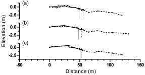
Beach profiles at Casla Vadanei. (a) Profile 16-3; (b) 16-2; (c) 16-1. (- - -), August 1996; (–––), September 1997. An elevation of 0 m corresponds to the elevation at the landmark.
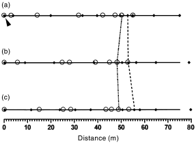
Shoreline position at Casla Vadanei. (a) Profile 16-1; (b) 16-2; (c) 16-3. (◆), Points measured in 1996; (○), points measured in 1997; (–––), direction of profiles; (- - -), shoreline position in 1996; (··-··), shoreline position in 1997. The arrowhead indicates the position of the landmark.
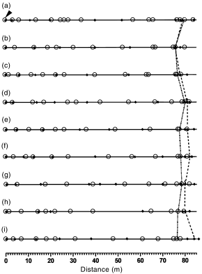
Shoreline position Sf. Gheorghe. (a) Profile 19-1; (b) 19-2; (c) 19-3; (d) 19-4; (e) 19-5; (f) 19-5; (g) 19-7; (h) 19-8; (i) 19-9. (◆), Points measured in 1996; (○), points measured in 1997; (–––), direction of profiles; (- - -), shoreline position 1996; (··-··), shoreline position in 1997. The arrowhead indicates the position of the landmark.
The central subsector has an east–west orientation (Perisor–Periteasca; Fig. 1), and is, therefore, somehow more protected from wave action. As long as the sediment load brought into this area remained high, the Perisor– Periteasca beaches were in accretion. Today, the accretion continues only in small areas ( 5, 6), the rest of this subsector being relatively stable.

Beach profiles at Periteasca Sud. (a) Profile 36-1; (b) 36-2; (c) 36-3. (- - -), August 1996; (–––), September 1997. An elevation of 0 m corresponds to the elevation at the landmark.
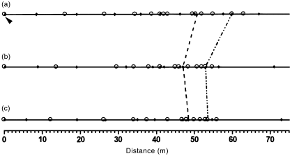
Shoreline position at Periteasca Sud. (a) Profile 36-1; (b) 36-2; (c) 36-3. (◆), Points measured in 1996; (○), points measured in 1997; (–––), direction of profiles; (- - -), shoreline position in 1996; (··-··), shoreline position in 1997. The arrowhead indicates the position of the landmark.
The southern subsector (Portita–Periboina; Fig. 1) is characterised by a small input of Danubian sediments, which is compensated for by an accentuated production of organogenic detritus. The shoreline orientation is northeast–southwest. The wave energy is much more important there than in the central subsector but less important than in the northern one. Therefore, the Portita and Periboina beaches suffer a mild process of erosion. The extent of shoreline retreat does not exceed several metres per year.
Southern sector
As in the northern sector, the southern part of the Romanian littoral zone being eroded. The infiltration of meteoric waters to the Villafranchian clay level induces important cliff slides. The direct wave activity on the base of the cliffs is also causes erosion, although to a smaller degree.
The littoral bars are characterised by an important sedimentary deficit that has induced continuous erosion and the general increment of beach-sediment grain size through the washing of the finer fraction ( Grigorita & Ariciuc 1995). The tourist beaches, especially Mamaia and Eforie, are also degrading rapidly because the harbour jetties from Midia and Constanta South practically block all the sedimentary material brought to this sector by the longshore current. The coastal protection engineering works that were meant to stop this phenomenon have moved the erosion downdrift.
CONCLUSIONS
The Romanian marine littoral zone is in a dangerous situation, mainly because of the anthropogenic interventions that were carried out without preliminary studies regarding the long-term consequences of these activities. The key to this problem is the increase of sedimentary material on the beaches. The best and most expensive solution is artificial sediment supplementation. For the northern sector, this solution cannot be economically justified. However, the situation is completely different for the littoral bars in the southern part. The profits that the tourist industry makes from the beach and the potential losses that would result from the destruction of tourist beaches require quick and drastic measures of protection against erosion.
It should also be mentioned that the decrease in the sediment quantity will continue because of the Portile de Fier II Dam and the decreases in riverbed erosion along the Danube.
Furthermore, it is predicted that in the next century, ocean levels will rise 0.3–1.15 m ( Hamilton 1991). This will alter the way the Danube waters mix with the seawater and cause sediment dispersion in the Danube mouth area, floods in lowland areas and a general retreat of the shoreline.


