Intralake training set of fossil Cladocera for paleohydrological inferences: evidence for multicentennial drought during the Medieval Climate Anomaly
ABSTRACT
We investigated an intralake surface sediment data set for fossil Cladocera from Lake Pieni-Kauro, eastern Finland, with an objective to develop a paleohydrological inference model for lake level reconstructions. The Cladocera assemblages showed high heterogeneity among the sampling sites according to the water depth gradient, thus enabling the construction of a quantitative inference model for water level reconstructions. The strongest model was developed using weighted averaging with classical deshrinking regression. This model had a jackknifed coefficient of determination of 0.79 and a root mean squared error of prediction of 0.79 m. We tested the performance of the model on previously available Cladocera stratigraphy and Cladocera-based and chironomid-based lake level reconstructions from Lake Iso Lehmälampi, southern Finland. The lake level reconstructions, based on different proxies and independent inference models, showed high levels of similarity, indicating a period of lower water table during the Medieval Climate Anomaly around 1000 ad. The results suggest that the applicability of intralake paleohydrological models may not be regionally restricted when applied to similar lake types and, therefore, provide an alternative perspective on paleolimnological training set design and paleoclimatological inferences. Copyright © 2011 John Wiley & Sons, Ltd.
INTRODUCTION
Local hydrology within a single lake basin is controlled by regional climate affecting water input (precipitation, river and surface inflows) and output (evapotranspiration, river outflow). In the northern hemisphere, these regional hydrological parameters are partly regulated by the atmospheric circulation pattern of the North Atlantic Oscillation (NAO) (Lamb and Peppler, 1987; Hurrell, 1995; Yu and Harrision, 1995), which consequently controls the strength of westerly winds and amount of moisture coming from the Atlantic Ocean. In addition, many catchment characters of lake basins, such as size, topography and vegetation influence the local hydrological cycles. Currently, and in the near future, global warming is severely altering hydrological processes by changing patterns in precipitation and evapotranspiration (i.e. effective moisture) that is inevitably reflected in lakes and rivers and their biota (Rouse et al., 1997; Carter et al., 2004; Jylhä et al., 2004).
Hydrological patterns, and catchment and basin morphology determine lake levels and, accordingly, the spatial variations in aquatic submerged, floating-leaved, and emerged macrophytes (Brönmark and Hansson, 2005). Moreover, within-lake variations in aquatic vegetation influence the habitat diversity of the littoral zone and the extent of the pelagic zone. Changes in water depth, aquatic vegetation and substrata within lake basins create a variety of microhabitats to benthic, vegetation-associated, and planktonic organisms. Some of these aquatic organisms, such as water fleas (Cladocera), diatoms (Bacillariophyta), and midges (Diptera: Chironomidae, Chaoboridae) preserve as identifiable fossil remains in lake sediments (Smol, 2008). Because it is known that many hydrological parameters affect the distribution of these organisms, they have been used as paleohydrological indicators to detect, for example, water level fluctuations, hydroseral development and river discharge changes (e.g. Korhola, 1990; Ludham et al., 1996; Hofmann, 1998). Earlier studies focused on the indicator value of particular habitat-specific species or communities using Cladocera (Alhonen, 1970; Korhola, 1990; Sarmaja-Korjonen, 2001), Chironomidae (Hofmann, 1998) and diatoms (Ludham et al., 1996). Later on, as modelling methods developed, paleohydrological inference models and numerical reconstructions of different hydrological parameters, such as lake levels (Korhola et al., 2000, 2005; Luoto, 2009; Luoto et al., 2010; Luoto and Sarmaja-Korjonen, 2011), were established.
Most paleohydrological inference models have been constructed by using a data set collected from multiple lakes along a water depth gradient using a single sample per lake (Korhola et al., 2000; Luoto, 2009; Nevalainen et al., 2011). However, new and promising developments in paleohydrological training set design have recently been established through the use of local and intralake data sets in fossil midge and diatom research (Kurek and Cwynar, 2009; Laird et al., 2010, 2011; Luoto, 2010, 2011). These data sets are constructed, so that several surface sediment samples are collected from one lake basin. Although it is documented that species assemblages of Cladocera also have clearly heterogeneous within-lake distribution in surface sediments according to some hydrological parameter (Kattel et al., 2007; Nevalainen 2011a, 2011b), this group has not yet been utilized in developing local training sets.
Here, our objective is to develop a paleohydrological inference model from an intralake Cladocera data set and apply the model to a previously available Cladocera stratigraphy for reconstructing lake level fluctuations over the past 2000 years. A particular point of our interest is on the Medieval Climate Anomaly (MCA), which has been suggested to be a period of decreased effective moisture in Finland (Helama et al., 2009). In this study, we test whether different reconstructions, based on different proxies (Cladocera and Chironomidae) and inference models (intralake and multilake), show similar trends and synchronized changes in effective moisture.
MATERIALS AND METHODS
Study sites
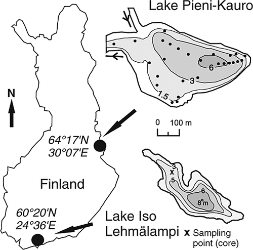
Lake Pieni-Kauro, from where the intralake data set originates, is located in eastern Finland (Figure 1), and the catchment of the lake complex is scarcely inhabited and densely forested mainly by boreal coniferous forest. The Saavanjoki River enters the lake from the north and the main outlet in the western side of the basin connects the lake to another lake (Kaurojärvi) at the same altitude and a smaller outlet drains towards south. Lake Pieni-Kauro is a dystrophic lake with a surface area of ~30 ha and maximum depth of 7.3 m. A detailed description of the study site is provided by Luoto (2010). The downcore study site, Lake Iso Lehmälampi, is situated in southern Finland, ~500 km southwest from Lake Pieni-Kauro (Figure 1). Lake Iso Lehmälampi was chosen for the study as a test site because in previous studies (e.g. Sarmaja-Korjonen, 2001; Nevalainen et al., 2008), the lake has proven to have experienced water level fluctuations and the sedimentary Cladocera stratigraphy is previously available (Nevalainen et al., 2008). The catchment of the lake consists mainly of bedrock outcrops and paludified patches, with boreal coniferous forest. The lake is oligotrophic and acidic with a pH of ~5.5. The surface area is ~5.1 ha and maximum depth is 8.1 m. More detailed site description is given by Nevalainen et al. (2008).

Sediment samples
Data set of 34 surface sediment samples (topmost 1 cm) from Lake Pieni-Kauro and Saavanjoki River were collected from a boat with a Limnos-type gravity corer (Kansanen et al., 1991) in October 2008. The sampling sites were originally selected to represent differences in water depth, substrata, vegetation and river flow (Luoto, 2010). Water depth (0.46–7.33 m) from the sampling sites was measured with a plumb line during the coring. The sediment samples were stored in plastic bags at +4 °C and sub-samples were treated later in laboratory by heating them in 10% KOH for 20 min, washing and sieving through a 40 µm mesh under running water, and centrifuging at 4000 rpm for 10 min (Szeroczyńska and Sarmaja-Korjonen, 2007). The samples were then mounted in safranine-stained glycerol jelly on microscope slides and analysed for their Cladocera composition under light microscope with 100–400× magnifications. A minimum of 300 cladoceran remains (carapaces, headshields, postabdomens, ephippia) were enumerated and identified on the basis of Szeroczyńska and Sarmaja-Korjonen (2007), and the most abundant remains of each taxa were chosen to represent the number of individuals. Only 31 of the 34 samples contained enough sediment and/or cladoceran remains for fossil Cladocera analysis. Stream samples were rejected from this study, because they potentially cause bias and overoptimistic model performance statistics following deviant species composition unrelated to water depth. After removing the stream samples, 27 lacustrine samples remained as the basis for the water-depth calibration set.
The sediment core from Lake Iso Lehmälampi was collected through ice using a Limnos gravity corer in February 2005. The sampling site (water depth 4.12 m) was selected from the shallower part of the lake basin (Figure 1) to get a better representation of the littoral cladoceran taxa (Chydoridae). The 24 cm sediment sequence consisted of homogenous fine detritus gyttja without any major changes in its organic content (Nevalainen et al., 2008). The sediment core, subsampled at 1 cm intervals in the field, was prepared for Cladocera analysis following the procedure described previously (Szeroczyńska and Sarmaja-Korjonen, 2007). The applied age-depth model based on radiocarbon dates and detailed description of the sampling and sample preparation procedures are presented in Nevalainen et al. (2008). The radiocarbon dating results for the Lake Iso Lehmälampi core are summarized in Table 1.
| Sediment depth (cm) | Material dated | Age bp | Age cal. bp | Age ad |
|---|---|---|---|---|
| 13–14 | Tree fragment | 930 ± 30 | 855 ± 46 | 1095 ± 46 |
| 18–19 | Bulk sediment | 1530 ± 30 | 1438 ± 53 | 512 ± 53 |
| 24–25 | Bulk sediment | 1910 ± 30 | 1861 ± 28 | 89 ± 28 |
- AMS, accelerator mass spectrometry.
Model development and water-depth reconstruction
Several techniques were tested to develop the best paleohydrological inference model (transfer function) for lake level. These techniques included weighted averaging (WA), weighted averaging-partial least squares (WA-PLS), PLS, Gaussian logit model (i.e. maximum likelihood), and modern analogue technique (MAT) (Juggins, 2007). The strongest model was considered to have the highest cross-validated coefficient of determination (r2jack) and lowest prediction error [root mean squared error of prediction (RMSEP)] and lowest mean and maximum biases in jackknife residuals. The WA taxon optima, the inference models and reconstructions were run and developed with the programme C2, version 1.5.1. (Juggins, 2007).
A previously available fossil Cladocera record from Lake Iso Lehmälampi, originally published in Nevalainen et al. (2008), was used as a test subject for the water-depth inference model and to provide a lake-level reconstruction over the past 2000 years. The validity of the reconstruction was tested by calculating the proportion of taxa from each fossil assemblage that was represented in the modern calibration set (cut-off for samples with poorly represented assemblages <95%), by examining whether the samples have good modern analogues in MAT (threshold for good assemblage <5% chord distance) and by comparing whether the modern measured values exceeded the topmost inferred value by more than the model's RMSEP. Furthermore, the validity was tested by comparing the reconstruction results with a Cladocera planktonic:littoral ratio (P : L) (Nevalainen et al., 2008), with a Cladocera-based reconstruction using an independent multilake calibration set (Nevalainen et al., 2011; Table 2), and with an independent proxy reconstruction from the same lake (Luoto, 2009; Table 2).
| Intralake, Cladocera | Multilake, Cladocera | Intralake, midge | Multilake, midge | |
|---|---|---|---|---|
| Technique | WAclassical | MAT | WA-PLS | WA-PLS |
| r2jack | 0.79 | 0.58 | 0.76 | 0.68 |
| Mean bias(m) | −0.05 | 0.05 | 0.03 | 0.04 |
| Max. bias (m) | 1.74 | 2.86 | 1.95 | 2.02 |
| RMSEP (m) | 0.79 | 1.09 | 0.94 | 0.78 |
- WA, weighted averaging; MAT, modern analogue technique; WA-PLS, weighted averaging-partial least squares; RMSEP, root mean squared error of prediction.
RESULTS
The distribution and relative abundance of cladoceran taxa in the intralake surface-sediment samples from Lake Pieni-Kauro are originally illustrated in Nevalainen (2011a). The most abundant euplanktonic taxa were Bosmina (Eubosmina) Seligo and Daphnia Müller. Most of the littoral taxa were chydorids, of which Alonella nana (Baird), Alona affinis (Leydig), Acroperus harpae (Baird) and Eurycercus Baird were most frequent. Euplanktonic Eubosmina and Daphnia were most abundant in the deepest samples and Bosmina longirostris (Müller), Eurycercus and Alona affinis showed preferences for the intermediate depths. The shallowest samples were dominated by Alonella nana, Chydorus sphaericus s.l., Alona rustica Scott and Alona guttata var. tuberculata.
The species assemblages from the Lake Iso Lehmälampi core are originally presented in Nevalainen et al. (2008). In the core, the most abundant taxa were the Bosmina (Eubosmina) dominating in the beginning and in the latter half of the core and the littoral Alonella nana, which dominated between ca. 19 and 14 cm. Other frequent littoral species included Alona affinis, Acroperus harpae, and Alonella excisa (Fischer).
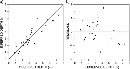
The strongest water-depth inference models were developed with WA using classical deshrinking regression; the model's r2jack was 0.79 and RMSEP 0.79 m, with mean and maximum bias of −0.05 and 1.74 m, respectively (Figure 2, Table 2). The three deepest samples showed underestimated inferred water depth that was nevertheless always <1 m lower than the measured depth. Largest biases were found from samples at ~4 m.

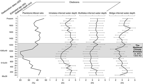
The water level fluctuations in Lake Iso Lehmälampi inferred using the intralake calibration model from Lake Pieni-Kauro varied between 2.7 (at 16 cm) and 4.6 m (at 9 cm) (Figure 3). Between 24 and 20 cm, the water level was at ~4 m and between 19 and 13 cm at ~3 m. The water level again increased from 12 cm onwards, but slightly decreased between 3 and 2 cm. The inferred water level for the topmost sample was 4.32 m, whereas the measured depth was 4.12 m showing an overestimation of only 0.2 m, which is clearly within the model's RMSEP. All fossil samples had good taxa representativeness (>95%) in the calibration set and good modern analogues (<5% chord distance). In addition, the reconstruction showed good correlation with the P : L ratio (Pearson's r = 0.90, p = <0.001) and with the multilake Cladocera-inferred water level reconstruction (r = 0.77, p = <0.001), but the correlation was not as strong with midge-inferred water level reconstruction (r = 0.38, p = 0.06). All of the reconstructions identified a lower lake level period, which culminated around 1000 ad (Figure 3).

DISCUSSION
Development of a new paleohydrological inference model
The presented Cladocera-based paleohydrological inference model (Table 2, Figure 2) was developed using an intralake calibration set exploiting surface sediment samples along a water depth gradient. This model is based on the implication that cladoceran remains accumulate post-mortem in proximity of their original littoral or planktonic habitats, and, therefore, local cladoceran assemblages represent unique intralake environmental conditions (Nevalainen, 2011a, 2011b). This is the first attempt to develop a Cladocera-based site-specific transfer function from surface-sediment samples from a single lake basin, although quite similar studies have been performed using fossil midges (Kurek and Cwynar, 2009; Luoto, 2010, 2011). The site-specific (one lake with 29 surface sediment samples) water-depth inference model by Kurek and Cwynar (2009) had favourable performance with r2boot of 0.90 and RMSEP of 1.76 m. The inference model by Luoto (2010) from Lake Pieni-Kauro also performed well, having slightly reduced performance statistics (r2jack 0.76, RMSEP 0.94) compared with the present Cladocera-based model (Table 2). The present model's relatively good performances (Figure 2, Table 2) imply that the intralake Cladocera-based models are capable of performing quantitative estimates on past paleohydrological conditions for paleoclimatological use. The residual structure of the present models illustrated a small underestimation of depth for deep sites (Figure 2b) that is a common feature in WA-based water depth-models (Luoto, 2009, 2010). This may cause underestimation in inferred values during events of high lake level.
The findings that water depth strongly influences the intralake Cladocera assemblages are in agreement with the single previous intralake study by Kattel et al. (2007) and the many previous multilake studies on cladocerans from various regions (Korhola, 1999; Amsinck et al., 2006; Sweetman and Smol, 2006; DeSellas et al., 2008; Nevalainen et al., 2011). The influence of water depth on the cladoceran species distribution is obviously indirect through habitat distribution and driven by, for example, patterns in primary production, planktivorous fish abundance, substrata type and ultraviolet radiation (Amsinck et al., 2006; Sweetman and Smol, 2006; Nevalainen, 2011a, 2011b).
Cladocera-inferred lake-level changes in Lake Iso Lehmälampi
The application of the Cladocera-based intralake inference model developed from surface sediments in Lake Pieni-Kauro to the sediment core from Lake Iso Lehmälampi showed a result that was similar in its trends compared with the Cladocera P : L ratio (Nevalainen et al., 2008), as well as the water-level reconstruction using an independent multilake Cladocera calibration model (Nevalainen et al., 2011) (Figure 3). It has been previously shown that the P : L ratio, which was coined by Alhonen (1970), correlates strongly with observed depth in Finnish lakes and with Cladocera-inferred depth using the Finnish multilake calibration set (Nevalainen et al., 2011). The present results (Figure 3) indicate that the same signal of lake level changes can also be derived using an intralake Cladocera-water depth model as the present reconstruction correlated strongly with the P : L ratio (r = 0.90, p = <0.001) and with the multilake Cladocera-based reconstruction (r = 0.77, p = <0.001). When comparing the present reconstruction against an independent proxy-record of midge-inferred lake level from the same lake, the results are in agreement (r = 0.38, p = 0.06).
In general, all of the records showed similar trends; elevated water level (~4 m) at ca. 200 ad that was followed by a decreasing trend towards ca. 1000 cal. BP (~3 m). When observing the details in individual reconstructions, there is more variation in the timing and duration of the low lake level phase (Figure 3). The present reconstruction suggested low and stable lake level phase to have occurred between 800 and 1000 ad, the multilake Cladocera-based inference detected constantly low water levels during a longer period ca. 400–1000 ad, and midge-based reconstruction showed a distinct short minimum at around 1000 ad. All the compared records indicated that the lake level was again elevated (~4 m) at ca. 1200 ad and remained relatively high during the rest of the late Holocene (Figure 3). The midge-inferred water depth indicated a slight decrease at ca. 1400 ad and an increase at ca. 1700 ad, but these events are not apparent in the Cladocera-based reconstructions. Midges are known to respond closely also to changes in hypolimnetic oxygen condition and temperature, and, hence, the changes in midge assemblages at the time of the Little Ice Age might have caused biases (although likely within the model's RMSEP) into the lake level reconstruction (Luoto and Salonen, 2010). In fact, the sample at 4 cm was identified as having midge assemblage with ‘poor’ fit to water depth (Luoto, 2009), and, therefore, we interpret the Cladocera-based reconstructions more reliable at this depth.
The lake-level reconstructions over the past ca. 300 years were generally in good agreement (Figure 3). A slightly decreasing water level trend towards ca. 1800 ad that was followed by an increase towards the present was synchronous with all the compared reconstructions, except the Cladocera-based inference using the multilake data set, which showed basically unchanged lake level from ca. 1300 ad onwards. Overall, the multilake Cladocera-inferred water level indicated the lowest magnitude in lake level, although in general, the trends were in correspondence. It is also worth mentioning that Cladocera-based and diatom-based reconstructions of water depth from several cores across a littoral-offshore transect taken from the southern and deeper parts of Lake Iso Lehmälampi by Sarmaja-Korjonen and Alhonen (1999) and Sarmaja-Korjonen (2001) were in agreement with our present results showing the same trends in lake level dynamics, despite their much coarser time resolution.
The aim of this study was to examine whether the model developed here could provide evidence for the multicentennial megadrought in southern Finland during the MCA (ca. 800–1300 ad). Helama et al. (2009) identified this event from tree-ring series from southern Finland and connected it with a coinciding global El Niño – Southern Oscillation (ENSO) drought pattern. Evidence from eastern Finland indicate that the MCA was probably related to a positive NAO-phase characterized by high summer temperatures, low summer precipitation, but increased winter precipitation (Luoto and Helama, 2010). Mann et al. (2009) and Trouet et al. (2009) also showed that a persistent phase of positive NAO prevailed during the MCA at a larger scale. In addition to ENSO and NAO (e.g. Cobb et al., 2003), the MCA may have been coincident with the long-term solar activity maximum (Jirikowic and Damon, 1994) and an anomalous phase of thermohaline circulation with intensified North Atlantic deep water formation (Bianchi and McCave, 1999; Bond et al., 2001). At least to some extent, the climatic forcings may have been coupled (Schindell et al., 2001; Mann et al., 2005). The Cladoceran-based lake-level reconstructions cannot separate between winter and summer conditions in definite, but it can be assumed that as the Cladocera have active periods during the summer and they remain dormant through the winter (Nevalainen and Sarmaja-Korjonen, 2008), they are likely strongly indicative of summer conditions. We hypothesized to find a lake level decline in Lake Iso Lehmälampi during the MCA, as the result of a decline in effective moisture (balance of evaporation and precipitation) during this climatic episode. The long-term lake level in Lake Iso Lehmälampi can be considered to have been dictated by changes in effective moisture, because the basin has no natural outlets and shallow enclosed basins without outlets are especially likely to respond to changes in precipitation and evaporation (Mason et al., 1994, Sarmaja-Korjonen et al., 2005).
According to Helama et al. (2009), precipitation began to reduce from ca. 800 onwards and continued until ca. 1200 ad. Maximum air temperature and minimum precipitation during the MCA occurred at ca. 1000 ad (Luoto and Helama, 2010). In our present reconstruction, the lake level began to decrease already at ca. 600 ad. In fact, the reconstructions by Luoto and Helama (2009) showed low regional precipitation at ca. 600 ad and only a peak in precipitation at ca. 800 ad, which is not evidenced by the records shown in Figure 3. In general, the timing of the decreased lake level in Lake Iso Lehmälampi during the MCA is in agreement with the regional precipitation data and suggests that multicentennial drought (Helama et al., 2009) prevailed in the southern parts of Finland. In the current data (Figure 3), the magnitude of water-level change was in agreement among the different records, but some differences were found in the extend of the dry climate period and in the timing of the minimum lake level, which was, however, always during the general timing of the MCA (Esper et al., 2002) around 1000 ad.
CONCLUSIONS
The present results indicate great potential in using intralake assemblages of fossil Cladocera to develop water-level inference models. The model developed here performed well with improved coefficient of determination and prediction error compared with the previous Finnish Cladocera-based multilake model and midge-based intralake and multilake models. The results from the present lake-level reconstruction from Lake Iso Lehmälampi showed consistent results with previous reconstructions. This distinct reproducibility of results together with successful reconstruction validation procedures provides evidence that the present lake level reconstruction is valid. The lake level records suggest that the MCA was indeed characterized by generally decreased water level, although the decrease began already before the generally accepted timing of the MCA. However, this may simply be due to the relatively coarse chronological control of the core from Lake Iso Lehmälampi. Overall, the present results provide evidence that similar signals of water level can be recovered from lake sediment cores using an intralake and multilake Cladocera-based inference models and that a multicentennial megadrought prevailed in southern Finland approximately at the time of the MCA. Furthermore, the results also imply that intralake inference models are not necessarily bound to their site of origin, but they can be applied on a geographically wider scale when the core taxa assemblages are similar to the training data.
ACKNOWLEDGEMENTS
Financial support was provided by Waldemar von Frenckell's Fund and the University of Helsinki Fund (Mathematics and Science Fund) for L.N. and by the Kone Foundation for T.P.L. This paper is a contribution to the INFER (INtralake Fossil invERtebrate Assemblages) and LOSER (LOng-term climate impactS on lakE tRophic status) projects. We thank the anonymous reviewer for constructive comments, which greatly improved our manuscript.


