Freshwater conservation planning informed and validated by public participation: The Ebro catchment, Spain, as a case study
Abstract
- Freshwater ecosystems generally lack adequate protection. In this regard, defining clear and objective conservation criteria through public participation is extremely important, as it can greatly enhance the feasibility of the conservation plans by building credibility, salience, and legitimacy.
- This article presents an exercise of systematic freshwater conservation planning informed and validated by public participation using river protected areas (RPAs) in the Ebro catchment, Spain, as a case study. A public participation process was performed to define the conservation criteria that RPAs should meet, resulting in a detailed list of conservation features and constraints that were poorly covered by the present network of RPAs in Spain.
- The present network of RPAs failed to adequately protect aquatic biodiversity, as 48% of the taxa did not meet the conservation target, including seven species of vulnerable invertebrates and three of vulnerable fish. marxan was used to identify a minimum set of additional areas that would help to meet the conservation target by adequately representing all conservation features and by increasing the efficiency of the network of protected areas. When marxan was run without restrictions, none of the present RPAs was selected, suggesting that the current network of RPAs is not efficiently meeting the conservation demands expressed through public participation.
- Overall, this study shows that combining public participation and systematic conservation planning could result in more efficient and enhanced protection of freshwater ecosystems by integrating a wide variety of conservation preferences into the design of RPAs. Also, according to the results, having detailed and updated information on the distribution of invasive and endangered species, as well as increasing the frequency and spatial extension of ecological monitoring, are key to meeting the public demands of enhanced freshwater biodiversity protection and the preservation of sites with high ecological value.
1 INTRODUCTION
Freshwater ecosystems are among the most extensively impaired ecosystems on Earth (Carpenter, Stanley, & Vander Zanden, 2011). They are affected by a myriad of stressors, such as the modification of natural flow regimes, water chemistry, physical habitat connectivity, and the presence of invasive species (Dudgeon et al., 2006; Malmqvist & Rundle, 2002; Meybeck, 2003). The pressure exerted by these stressors is reaching alarming levels. For example, 48% of global river volume is moderately to severely affected by flow alteration, and this will be almost doubled in the near future assuming the completion of all dams that are planned or already under construction (Grill et al., 2015). These conditions are posing significant risks to freshwater biodiversity and human welfare (Vörösmarty et al., 2010). Indeed, freshwater biodiversity is drastically decreasing (Collen et al., 2014; Dudgeon et al., 2006; Pereira et al., 2010), with the extinction rate for freshwater species being four to five times higher than that of terrestrial and marine ecosystems (Naiman et al., 2006). In addition, the degradation of freshwater ecosystems diminishes the supply of drinking water and irrigation water, as well as affecting other valuable services such as the regulation of greenhouse emissions and protection against floods and droughts (Dodds, Perkin, & Gerken, 2013).
Attention to the conservation and management of freshwater ecosystems has increased exponentially over recent decades (Hermoso, Abell, Linke, & Boon, 2016), yet these ecosystems generally lack adequate protection (Abell, 2002; Saunders, Meeuwig, & Vincent, 2002; Suski & Cooke, 2007). For example, Nel et al. (2007) showed that only 16 out of the 112 main river ecosystems in South Africa were moderately to well represented within protected areas. Similarly, Herbert, Mcintyre, Doran, Allan, and Abell (2010) found that terrestrially oriented protected area networks provided only weak protection for aquatic features in Michigan, USA. Although freshwater protected areas are still scarce when compared with terrestrial and marine reserves (Finlayson, Arthington, & Pittock, 2018), examples can be found around the world. In the USA, the Wild Scenic Rivers System is intended to preserve rivers in a free-flowing condition (Wild and Scenic Rivers Council, 2018). In Australia, the National Water Initiative Clause 25(x) states that water access entitlements and planning frameworks will ‘identify and acknowledge surface and groundwater systems of high conservation value and manage these systems to protect and enhance those values’ (National Water Commission, 2004). In South Africa, the National Freshwater Ecosystem Priority Areas project identified areas for freshwater biodiversity conservation, named freshwater ecosystem priority areas (FEPAs) (Nel et al., 2011). These FEPAs were designed to meet the national biodiversity goals for freshwater ecosystems (Nel et al., 2016). In Europe, the Habitats Directive (Council of the European Communities, 1992) served to establish the EU-wide Natura 2000 ecological network of protected areas, which included 16 freshwater habitats and many freshwater species, and is intended to safeguard natural habitats and wild fauna and flora against potentially damaging developments. In addition, the Water Framework Directive (WFD; Council of the European Communities, 2000) urges member states to protect freshwater ecosystems through specific management actions. In particular for Spain, the 11/2005 Spanish law established that all river catchments should include river protected areas (RPAs, similar to FEPAs; original term in Spanish: ‘reservas naturales fluviales’) within their planning. The implementation of this law has resulted in a current network of 213 RPAs covering more than 3000 km of rivers (Urquiaga & Martín, 2017).
Most frequently, the design and implementation of freshwater protected areas has followed arbitrary criteria. For example, the RPAs in Spain exclusively comprise rivers and streams that are at ‘high’ or ‘good’ ecological status (i.e. according to the WFD), which were assumed to have the greatest aesthetic, hydromorphological, and conservation value (Urquiaga & Martín, 2017). Defining clear and objective conservation criteria through public participation is extremely important, as it can greatly enhance the feasibility of the conservation plans by building credibility, salience, and legitimacy (Dietz & Stern, 2008; Nel et al., 2016); however, the translation of the different stakeholder interests into explicit criteria that can be used for conservation planning is challenging (Ban et al., 2013). In this regard, systematic conservation planning is evolving into a promising tool that can be used not only to identify priority areas for meeting multiple conservation criteria in a cost-effective manner (Ban & Klein, 2009; Margules & Pressey, 2000; Naidoo et al., 2006; Turak, Linke, Abell, Thieme, & Hermoso, 2018), but also to increase the viability of conservation plans by promoting consensus among stakeholders. For example, the combination of this tool with public participation and strong institutional engagement resulted in feasible and credible conservation plans for freshwater ecosystems in South Africa (Nel et al., 2011). FEPA maps designed and validated through strong public engagement resulted in numerous FEPAs being proposed for the highest level of protection in terms of the National Water Act, formalized into bioregional planning policy, and used in a number of regulatory decision-making contexts (Nel et al., 2016). These kinds of conservation planning exercises remain scarce, however, and the conservation criteria that freshwater protected areas should meet are still under debate.
This article presents an exercise of systematic freshwater conservation planning informed and validated by public participation using the Ebro catchment, Spain, as a case study. The Ebro is the largest catchment in Spain, with a drainage area of 85 550 km2 (Sabater, Muñoz, Feio, Romaní, & Graça, 2009). This catchment is especially interesting because it has high environmental heterogeneity (Bejarano, Marchamalo, de Jalón, & del Tánago, 2010; López-Moreno et al., 2011), it harbours several water-related social conflicts (Garrido, Martínez-Santos, & Llamas, 2006; Milano et al., 2013; Tàbara & Ilhan, 2008), it is highly populated and intensively cultivated (Martín, Arias, & Corbí, 2006; Mondy, Muñoz, & Dolédec, 2016), and it has centralized and accessible data (Ebro Hydrographic Confederation, 2016). The main objectives of the study were: (i) to establish the conservation criteria that RPAs should meet through a public participation process involving policymakers, stakeholders, scientists, and the general public; (ii) to incorporate these conservation criteria into the design of RPAs following a systematic conservation approach; (iii) to obtain a network of RPAs fitting these criteria; (iv) to assess the performance of the proposed approach by comparing the conservation efficiency of the resulting network of RPAs and the present network of RPAs implemented by Spanish legislation; and (v) to validate the resulting network of RPAs through the public participation process.
2 METHODS
The study pivoted around public participation, which was a key aspect to establish the conservation criteria that RPAs should meet and to validate the feasibility of the identified RPAs (Figure 1). The availability of data and scientific expertise were key to translate the conservation criteria into quantitative conservation features and costs that could be used by the systematic conservation planning software marxan (Ball & Possingham, 2000) to identify priority RPAs. The conservation efficiency of the current and the resulting networks of RPAs were compared by running marxan under different scenarios.

2.1 Public participation process
A survey was designed (Appendix S1) to assess the public knowledge about the RPAs in Spain and to establish and to rank the conservation criteria that they should meet. The survey was launched through a wide variety of distribution channels at the Spanish level (e.g. Spanish nature conservation organizations, research centres, scientific societies, and public entities), but some responses arrived from other countries (being considered only for the analysis of the more general issues, i.e. questions 7–11 of the survey). A total of 86 fully completed surveys were received: 82 from Spain, two from Brazil, one from the UK, and one from the USA. The surveys from Spain came from 11 different autonomous communities (out of the 17 in Spain), including six of the nine communities of the Ebro catchment. University professors comprised 28% of the respondents (and most of them worked on biological or environmental topics), 26% came from non-governmental organizations, 15% came from public administrations (including environmental agencies and the Ebro water agency), and the rest (31%) were from environmental consultants, politicians, teachers, actors, or nurses, among other professional profiles (Appendix S1). Unfortunately, the survey was not answered by many respondents outside the environmental field, despite it being largely distributed through different channels.
In addition to the survey five workshops were organized (Appendix S2): three initial workshops (i.e. before using marxan to identify priority RPAs) were conducted at different locations in the Ebro catchment (Logroño, Pamplona, and Zaragoza) to decide the conservation criteria that RPAs should meet, and two final workshops were conducted at mid and low sections of the catchment (Sant Carles de la Ràpita and Zaragoza) to present and discuss the maps of RPAs resulting from marxan using different scenarios (see section 2.2.3). Overall, the outputs from the workshops served to identify the main goals that RPAs should achieve in terms of conservation features (items to be protected by RPAs) and constraints (items that could limit the feasibility of an RPA).
2.2 Identification of priority RPAs
2.2.1 Definition of planning units and data modelling
The Ebro catchment was divided into smaller planning units (PUs), i.e. stream reaches and their contributing catchments, which were used as the minimum management units for the prioritization exercise. In total, 9964 PUs were delineated from a 25-m digital elevation model (sourced from the Ebro Hydrographic Confederation) using the archydro tool in arcgis 10.1 (ESRI, 2012) (Figure 2). The average length of all PUs was 3.30 ± 1.43 km and the average area was 9.36 ± 3.87 km2.

2.2.2 Distribution of conservation features
The list of prioritized criteria from the survey and the initial workshops was used to get a consensual list of conservation features (items to be protected by RPAs) that included stream types and biodiversity (see the Results section). Thus, a database was created including available information on the distribution of the different stream types and their associated biodiversity throughout the Ebro catchment. Stream morphological information was available from Díaz and Ollero (2005), who divided the streams into eight different types according to the stream slope and sinuosity (i.e. braided, meandering, and straight). Presence/absence data for diatoms, aquatic bryophytes, macroalgae, macrophytes, and aquatic macroinvertebrates were retrieved from the Geoportal of the Ebro Hydrographic Confederation (http://iber.chebro.es/geoportal/). These data were collected within the monitoring programme of the ecological status of surface water bodies, as required by the WFD (Council of the European Communities, 2000). Diatoms, bryophytes, macroalgae, macrophytes, and macroinvertebrates were sampled, identified, and used for assessing the ecological status of the streams following the standard methods described by the Ebro Hydrographic Confederation (2016). Data on fish were obtained from by Filipe et al. (2013), derived from EU project databases provided by BioFresh partners (for further details, see http://www.freshwaterplatform.eu/). The distribution of vulnerable and endangered species according to the International Union for Conservation of Nature (IUCN) Red List of Threatened Species was available for bryophytes, macroalgae, and macrophytes (Bañares, Blanca, Güemes, Moreno, & Ortiz, 2010), macroinvertebrates (Verdú, Numa, & Galante, 2011), and fish (Villarejo, 2002).
The information on the distribution (i.e. presence/absence) of stream types, diatoms, aquatic vegetation (i.e. bryophtyes, macroalgae, and macrophytes), macroinvertebrates, and fish was available for 4966, 268, 251, 267, and 698 PUs, respectively. Multivariate adaptive regression splines (MARS) models (Elith & Leathwick, 2007; Leathwick, Elith, & Hastie, 2006; Leathwick, Rowe, Richardson, Elith, & Hastie, 2005) were used to fill the gaps in their distribution. This technique uses piecewise linear segments to describe non-linear relationships between response and predictor variables, and has been shown to perform better than most of the more common predictive algorithms available in BIOMOD (the approach commonly used for developing ensemble models; Elith et al., 2006). The model was fitted using code provided by Elith and Leathwick (2007) for the mixture and flexible discriminant analysis (MDA) library within the free statistical software r (R Core Team, 2015). Environmental predictors were chosen for their likely functional relevance, and included topographic, geomorphological, and climatic variables compiled from different sources (Benda et al., 2016; Fernández, Barquín, Álvarez-Cabria, & Peñas, 2012; Peñas, Barquín, Snelder, Booker, & Álvarez, 2014; Table 1).
| Predictor variable | Source | Stream types | Biodiversity |
|---|---|---|---|
| Stream order | MARCE | X | |
| Stream width | MARCE | X | |
| Stream flow | MARCE | X | |
| Sinuosity | MARCE | X | |
| Slope | MARCE | X | |
| Elevation | MARCE | X | X |
| Catchment area | MARCE | X | X |
| Catchment geology | MARCE | X | |
| Temperature | WorldClim | X | |
| Precipitation | WorldClim | X | X |
| Isothermality | WorldClim | X |
- a MARCE: Development of a Spatial Framework for Integrated Catchment Management (http://marce.ihcantabria.es/).
- b WordlClim: WorldClim - Global Climate Data. Free climate data for ecological modelling and GIS (http://www.worldclim.org/bioclim).
Model performance was assessed through the area under the receiver operating characteristic curve (ROC) (Fielding & Bell, 1997). The area under the ROC curve (AUC) was calculated through a 10-fold cross validation procedure, partitioning the entire dataset into training and testing data (Hastie, Tibshirani, & Friedman, 2001). Data were randomly divided into 10 exclusive subsets, and model performance was calculated by successively removing each subset, re-fitting the model with the remaining data, and then predicting the omitted data. The average error when predicting occurrence in new sites can then be calculated by averaging the AUCs across each of the subsets (Leathwick et al., 2005). We defined an AUC > 0.6 as acceptable model performance, following Fielding and Bell (1997). Sensitivity analysis was performed to explore the robustness of the models further (Appendix S3) by using the function sensitivity in the R package presenceabsence (Freeman & Moisen, 2008). This function calculates the proportion of observed positives that are correctly predicted and reflects the ability of the model to predict a presence given that a species actually occurs at a location. After the modelling exercise, the distribution of a total of eight stream types, 52 diatom species, 20 macrophyte species, 23 and 16 macroinvertebrate families and species, respectively, and 28 fish species were available (Appendix S4). A probability (ranging from 0 to 1) of the occurrence of each successfully modelled conservation feature at each PU was obtained using the function mars.predict (Elith & Leathwick, 2007). Then the function optimal.thersholds in the r package presenceabsence (Freeman & Moisen, 2008) was used to translate the probabilities of occurrence into the presence/absence of all modelled conservation features in each PU. When the MinROCdist parameter had a lower value than the predicted probability of occurrence of a given conservation feature at a given PU, the conservation feature was considered to be absent from that PU.
2.2.3 Selection of priority RPAs
The selection of priority RPAs was performed following a systematic conservation approach (Margules & Pressey, 2000), which aims to adequately represent all conservation features (i.e. items to be protected through the reserve network) at a minimum cost. This analysis was performed using the free software marxan (Ball & Possingham, 2000). marxan relies on a simulated annealing optimization algorithm to identify a minimum set of PUs that meet user-defined targets at a minimum cost. This is achieved by trying to minimize an objective function where three different parameters are accounted for: (i) the cost of all selected PUs; (ii) the penalty for not achieving the conservation targets for each conservation feature; and (iii) the penalty for not achieving solutions that are connected. In this study, the conservation features were defined according to the conservation criteria emerging from the public participation process (see Results section). Before running marxan it was necessary to set a conservation target for each conservation feature and a cost to be assigned to each PU. A target of five was set, i.e. each conservation feature had to be included in at least five different PUs of the final network of RPAs. Although this can be considered a low target, it represents more than 75% and 50% of the distribution range of 53 and 59 taxa (out of 119), respectively. So, by securing at least five occurrences of each conservation feature, the solution would cover a minimum of 75 and 50%, respectively, of the rarest features in the study area, ensuring an adequate representation.
As the economic cost of protecting a specific area is difficult to estimate, other surrogates (e.g. land use) are often used (Linke, Turak, & Nel, 2011; Naidoo et al., 2006). In this study, a set of variables that reflect different types of human pressures on freshwater ecosystems were used as surrogates of the potential economic cost of protecting the PUs (e.g. protecting a stream where little restoration effort is needed should have a low economic cost). These indicators included human land uses, the distance to the nearest dam, the ecological status of the streams, the riparian habitat quality index (Munné, Prat, Solà, Bonada, & Rieradevall, 2003), and the presence of invasive species. Information on these variables was available for all PUs, except for invasive species, which were modelled following the same procedure used to model the conservation features. This selection of surrogates was based on a combination of the conservation criteria defined through the public participation process (see Results section) and assumptions made on the potential economic cost of protecting the PUs. To merge all cost surrogates into a single cost variable, Spearman correlation tests were used and one of each pair of highly correlated variables was discarded. Then, the selected variables were combined through a factorial analysis with varimax rotation using the r package pysch (Revelle, 2016). Finally, variables were scaled from 0 to 1, and an averaged weight sum of both variables was performed using the variable loading in the first two axes of the factorial analysis as a weighting factor (Appendix S5).
Longitudinal connectivity along the river network was included in the optimization process by taking into account the effect of the distance between PUs on the strength of the connections (it is expected that the connection between two contiguous units is more important than between two distant units). Following the recommendations described in Hermoso, Linke, Prenda, and Possingham (2011), the inverse of the distance along the river network between each pair of PUs was used as an additional penalty in the objective function that marxan optimizes through the boundary-length modifier (BLM). In this way, if two contiguous units were not selected in the solution, a high penalty was applied in the objective function and, therefore, could result in a non-optimal solution being discarded. As a consequence, the solutions obtained in marxan should include connected sets of contiguous units along the river network. Given the important effect of the BLM (values that are too high may result in the selection of too many PUs, necessary to achieve highly connected solutions, requiring extensive RPAs that would be too difficult to implement), a calibration exercise was performed to obtain the value that maximized the connectivity with a minimum number of selected PUs. To do this, marxan was run using increasing BLM values (ranging from 0.01 to 5.00) and the connectivity achieved was plotted against the number of selected PUs (Appendix S6). The BLM value was selected at the inflection point of the curve (BLM = 0.1), from which small increments in connectivity could only be achieved by incorporating a high number of PUs in the solution.
Finally, different planning scenarios were used to compare the conservation efficiency of the resulting network of RPAs and the current network of RPAs implemented under Spanish legislation. This was achieved by modifying the ‘status’ of the PUs in the optimization process and locking them in or out of solutions. Two scenarios were compared: (i) no PUs were locked in or out, allowing marxan to include freely any PU within the final reserve system; and (ii) the PUs belonging to current RPAs were locked in, forcing marxan to include them within the final reserve system. Thus, the reserve system that marxan chooses with no restrictions (scenario 1) could be compared with the reserve system that would complement the current network of RPAs (scenario 2), providing information on the conservation efficiency of the current network of RPAs with the alternative RPAs identified by marxan. In total, 100 runs with 106 iterations were performed for each scenario, from which the best solution was selected by marxan. The resulting maps were discussed with the participants of the two final workshops (organized at Sant Carles de la Ràpita and Zaragoza) to find the most feasible scenario for implementation.
3 RESULTS
3.1 Public participation process
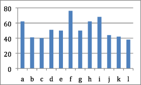
The detailed responses to the survey are provided in Table 2. Most of the respondents to the survey (79%) were unaware of the existence of RPAs in Spain; however, 80% of the respondents found them necessary and urgent. Also, most of the respondents considered that RPAs could include rivers altered by human action to some extent, as long as they have some ecological (50%) or social (25%) value, or a high or good ecological status according to the WFD (13%). When stating and ranking the conservation criteria that RPAs should meet, the protection and conservation of aquatic biodiversity (i.e. overall species richness) was the most important criterion, both in terms of the number of respondents (88% of respondents chose this target) and ranking (25% of respondents who chose this target considered it as the top priority). Other important criteria were the protection of fluvial dynamics and geomorphological processes, the protection of pristine streams, and the protection of ecological connectivity (80, 71, and 71% of respondents chose these criteria, respectively; 13, 25, and 1% of respondents who chose these criteria considered them as the top priority, respectively). The remaining criteria (Appendix S1) were selected by 44–58% of the respondents and included the protection of different components of biodiversity (e.g. endangered species), environmental stream flows, and historical and social heritage. The three initial workshops (i.e. aimed at identifying the conservation criteria that RPAs should meet) were attended by 74 people, representing 43 institutions (for details, see Appendix S2). The final conservation criteria identified as most important by the survey and the workshops included a mixture of biodiversity, geomorphological, ecological status, and hydrological connectivity elements (Table 3). Some of these were incorporated into marxan as conservation features, whereas others were used as conservation constraints (Table 3).
| Questions | Possible answers | % |
|---|---|---|
| 1. Are you aware of the existence of protected rivers and streams called ‘river protected areas’ (RPAs)? | Yes | 79 |
| No | 21 | |
| 2. Did you know in advance of this survey that there are river stretches and streams in the Ebro catchment declared as RPAs since 2015? | Yes | 60 |
| No | 40 | |
|
3. Do you know the number of RPAs declared in the Ebro catchment? (1)(2) Correct answer: c |
(a) Between 1 and 5 | 28 |
| (b) Between 6 and 10 | 9 | |
| (c) Between 1 and 5 | 41 | |
| (d) More than 15 | 22 | |
|
4. Do you have any idea of the total length in km declared as RPAs in the Ebro catchment? (1)(2) Correct answer: c |
(a) Between 0 and 75 km | 27 |
| (b) Between76 and 150 km | 17 | |
| (c) Between 151 and 225 km | 43 | |
| (d) Between 226 and 300 km | 0 | |
| (e) More than 300 km | 13 | |
| 5. Do you know any of the RPAs declared in the Ebro catchment? If yes, can you cite one in particular? (1)(2) | Yes | 56 |
| No | 44 | |
| 6. You consider that the implementation of RPAs in Spain is: | (a) Necessary and priority | 80 |
| (b) Not a priority but necessary | 16 | |
| (c) Not necessary | 4 | |
| 7. Do you think it should be essential that a river stretch or stream is in a pristine state (i.e. with little or no modifications resulting from human action) in order to be declared an RPA? You can choose more than one option. | (a) Yes | 12 |
| (b) Non-pristine river stretches or streams of interest for the conservation of species of interest or natural processes of singular river dynamics could also be declared | 50 | |
| (c) Non-pristine river stretches or streams of interest from a social point of view could also be declared (for example, interest in bathing areas, from a historical/symbolic point of view, etc.) | 25 | |
| (d) No, but in any case, they should be river stretches or streams in a good state of conservation and naturalness | 13 | |
|
8. What are the conservation criteria that RPAs should meet? If you choose more than one option, please number them according to your priority (with 1 being the highest priority).
The results of this question are expanded in Appendix S1 |
(a) Protection and conservation of river stretches and streams in very good state of conservation (pristine) (b) Protection and conservation of fish (c) Protection and conservation of aquatic macroinvertebrates (d) Protection and conservation of environmental flows (e) Protection and conservation of river banks and their associated vegetation (f) Protection and conservation of freshwater biodiversity (g) Protection and conservation of vulnerable and endangered species (h) Corridor function and ecological connectivity (i) Protection and conservation of natural geomorphological processes and fluvial dynamics (j) Protection and conservation of the natural heritage (k) Protection and conservation of historical and ethnographic heritage (l) Protection and conservation of river stretches and streams of scientific interest |
|
 |
||
| 9. You believe that the design of RPAs and their declaration as such should be based upon (you can choose more than one option): | (a) Scientific-technical criteria | 46 |
| (b) Social criteria | 23 | |
| (c) Economic criteria (cost of implementation of reserves) | 2 | |
| (d) All of the above | 29 | |
| 10. Do you know what the systematic conservation planning tools are? | (a) Yes | 23 |
| (b) No | 37 | |
| (c) I do not know exactly what it is, but I've heard something about it | 40 | |
| 11. Do you consider that there should be specific plans for the use and management of RPAs? | (a) Yes, because it is necessary to manage each RPA taking into account the specific objectives and conservation criteria that have motivated its declaration | 25 |
| (b) Yes, because it must be something required for any figure of protection of natural spaces | 7 | |
| (c) Yes, for the two previous reasons | 64 | |
| (d) No, because the RPA definition already clarifies what activities are allowed and nothing else is necessary | 1 | |
| (e) No, because they suppose an excessive cost of human and economic resources for the administration | 1 | |
| (f) No, for the two previous reasons | 1 | |
| (g) No, for other reasons | 1 | |
| 12. Have you or the organization that you belong to been officially consulted regarding the design and declaration of RPAs in the Ebro basin? | (a) No | 74 |
| (b) Yes, I was personally consulted because of my professional activity | 3 | |
| (c) Yes, I was consulted as a citizen | 0 | |
| (d) A conservation or environmental NGO which I belong to has been consulted | 10 | |
| (e) An association or citizen platform which I belong to has been consulted | 2 | |
| (f) A public administration that I work for or which I represent has been consulted | 5 | |
| (g) Yes, other options | 6 | |
| 13. Do you think that public participation is necessary for the design and implementation of RPAs? | (a) Yes, it is necessary | 55 |
| (b) It may be a complement to scientific-technical criteria and justifications | 42 | |
| (c) It is not necessary | 3 |
| Conservation criteria | Source of data | Type of data |
|---|---|---|
| Protection and conservation of aquatic biodiversity | Presence/absence of diatoms, bryophytes, macroalgae, macrophytes, aquatic invertebrates, and fish | Conservation feature |
| Protection of pristine streams | Ecological status of the streams under the European Water Framework Directive and land use | Conservation constraint |
| Protection of fluvial dynamics and geomorphological processes | Stream geomorphological typologies | Conservation feature |
| Ecological connectivity | Existence of dams and network distance between streams | Conservation constraint |
| Protection of environmental flows | Existence of dams | Conservation constraint |
| Conservation of endangered species | Distribution of endangered and vulnerable species | Conservation feature |
| Conservation of riparian vegetation | Riparian habitat quality index (Munné et al., 2003) | Conservation constraint |
3.2 Identification of priority RPAs
Scenario 1 (i.e. no PUs locked) resulted in a reserve system that included a total stream length of 854 km (2.6% of the stream length of the catchment) that did not include any of the current RPAs (Figure 3a). Scenario 2 (i.e. RPAs locked in) resulted in a reserve system with a total stream length of 1251 km (3.8% of the stream length of the catchment) (Figure 3b), with 385.42 km corresponding to the current network of RPAs for the Ebro catchment. In both scenarios all conservation features achieved the target set (i.e. a minimum of five occurrences). In scenario 2, the current network of RPAs already adequately represented 80 out of 147 conservation features (i.e. they occurred in at least five PUs). The 67 conservation features that did not reach the target under the current RPA network included seven species of vulnerable invertebrates and three of vulnerable fish. Among them, the macroinvertebrate species Gomphus graslinii and Margaritifera auricularia, and the fish species Anguilla anguilla and Salaria fluviatilis, were completely absent from the current network of RPAs. The PUs selected by marxan covered a wide range of environmental conditions within the catchment (i.e. from sites of high elevation to sites of low elevation, including both low-order reaches and the main section of the Ebro River), whereas the current RPAs were mostly located towards mountain reaches (Figure 3b).

3.3 Validating the network of RPAs
The two final workshops (i.e. aimed at presenting and discussing the networks of RPAs resulting from marxan) were attended by 20 people, representing 15 institutions (for details, see Appendix S2). The workshop participants chose scenario 2 as the most useful given that the current network of RPAs (Figure 2) has already been declared. Several concerns were raised during the workshop: (i) some of the streams included in the proposed network of RPAs (Figure 3b) are dry for most of the year; (ii) the conservation value of some conservation features (e.g. diatoms) might be low, and thus their weighting in defining the reserve network should be lowered; and (iii) some of the streams included in the reserve network were not of high or good ecological status and should be discarded from the reserve network. It was not possible to address concerns (i) and (ii) because no detailed hydrological data and information on the conservation value of each conservation feature was available. In contrast, concern (iii) could be addressed by locking out all PUs that were not at high or good ecological status from the analyses. However, this meant that only 40% of the total river network could be considered for the reserve design, as information on ecological status was not available for all PUs. In PUs where more than one assessment of the ecological status was available, e.g. PUs that contained multiple water bodies as defined by the WFD (i.e. ‘discrete and significant elements of surface water’; European Commission, 2003), the lowest value was selected as a conservative measure. The resulting network of RPAs running scenario 2 and locking out PUs that were not at high or good ecological status constituted a total stream length of 505 km (1.54% of the stream length of the catchment) (Figure 4). Most of the PUs selected by marxan in this scenario corresponded to reaches at high elevation. All of the conservation features achieved the target that had been set (i.e. a minimum of five occurrences); however, the mean distribution of the conservation features covered by the reserve (i.e. the number of PUs including the conservation feature in the reserve/total number of PUs containing the conservation feature) in this scenario (1.85 ± 1.43%) was lower than that included in scenarios 1 and 2 when no PUs were locked out (3.26 ± 1.14% and 4.07 ± 1.21%, respectively).

4 DISCUSSION
Engaging different groups (i.e. policymakers, stakeholders, scientists, and the general public) in the definition of the conservation criteria that RPAs should meet resulted in seven key conservation features and constraints (e.g. the protection of biodiversity, hydrological connectivity, and riparian habitats). This list of conservation features was largely unrepresented by the current definition of RPAs in Spain. This is not surprising because the design of the Spanish network of RPAs focused on streams under little or no human alteration (with a special emphasis on hydromorphology), considering biodiversity only indirectly through the selection of streams at high or good ecological status. Thus, it seems clear that the current network of RPAs does not fully meet public expectations. This is important because it can limit implementation and conservation success in the long term (Barmuta, Linke, & Turak, 2011). Interestingly, most of the conservation criteria selected through public participation in this study matched the goals used for identifying FEPAs in South Africa through public participation, although some important differences can be found between both approaches. According to Nel et al. (2016), freshwater protected areas should include areas ‘of known conservation importance by local experts’ and ‘align selection of priority areas with protected areas, to enhance conservation feasibility’, as well as ‘align selection of river priority areas with priority estuaries to promote the persistence of estuaries’. None of the above criteria were selected in the present study. Expert judgement and current protected areas are important criteria that should be taken into account when planning freshwater conservation and, although they were not explicitly stated, they were informally raised by some workshop participants. Thus, it is very likely that these criteria would have been included if the number of survey and workshop participants had been higher or the duration of the workshops had been longer. Regarding the selection of estuaries, we intentionally avoided pre-selecting specific areas in our conservation exercise, because the preference for certain regions or ecosystem types can be highly biased (i.e. people tend to confer higher conservation value to the ecosystems or species to which they are more tightly linked). Nevertheless, the available studies suggest that coastal ecosystems (e.g. estuaries and deltas) are especially important for the supply of goods and services (Costanza et al., 1997; Newton et al., 2018). There was one conservation criterion selected in this study that was not explicitly captured by FEPAs (Nel et al., 2016): the conservation of riparian vegetation (although the selection of ‘diversity of river ecosystems as coarse-filter biodiversity surrogates’ would probably include the protection of the different communities of riparian species). This suggests that the background of the people engaged in the participation processes can influence freshwater conservation priorities, but that some key goals (e.g. the protection of biodiversity, threatened species, and fluvial dynamics) are likely to be shared by most of the public.
This study shows that the current network of RPAs in the Ebro catchment fails to protect the overall freshwater biodiversity, even when setting a very low target of protecting at least five occurrences of each conservation feature: 48% of the conservation features did not reach the conservation target and some vulnerable species were not even represented in the RPAs. Other authors have pointed to the inadequate representation of freshwater species in protected areas. Hermoso, Filipe, Segurado, and Beja (2015a) found that the Natura 2000 network, despite covering more than 25% of the Iberian Peninsula, covers <20% of the range of freshwater species on average, and some species are absent from the network altogether. Guareschi, Bilton, Velasco, Millán, and Abellán (2015) found that 14 Iberian endemic beetle species with high vulnerability were completely absent from the national protected area network. This is related to the poor reserve design, which often neglects biodiversity requirements and ecosystem integrity (Hermoso et al., 2015a). It is important to recognize that those studies were focused on protected areas that were not specifically designed to preserve freshwater ecosystems, thereby suggesting that terrestrial reserves fail to protect freshwater biodiversity. This is something that has already been shown by many previous studies (Abell, Allan, & Lehner, 2007; Dudgeon et al., 2006; Strayer & Dudgeon, 2010), and relates mainly to the terrestrial notions of protected areas translating imperfectly to the attributes of river landscapes (e.g. a dendritic structure leading to the propagation of stressors). This study shows, however, that even freshwater protected areas, such as the RPAs designated under Spanish legislation, might confer insufficient protection for freshwater biodiversity. Similar flaws were found for the Wild and Scenic Rivers of the USA (Wild and Scenic Rivers Council, 2018), which left some water recharge hotspots completely unprotected and included a poor representation of aquatic species (Herbert et al., 2010). Thus, we encourage the use of systematic conservation planning to maximize the effectiveness of freshwater protected areas in furthering biodiversity conservation. This is important, as the limited investment in the protection of freshwater ecosystems and the growing water demand (Vörösmarty et al., 2010) call for a prioritization of conservation efforts (Nel et al., 2009).
Maintaining hydrological connectivity and the protection of native species against invasive species were further key conservation criteria identified through public participation. Several studies have stressed the importance of hydrological connectivity for favouring species dispersal (Bogan, Boersma, & Lytle, 2013; Cañedo-Argüelles et al., 2015; Erős, O'Hanley, & Czeglédi, 2018) and ecosystems processes (Benda et al., 2004; Pringle, 2003; Tockner, Pennetzdorfer, Reiner, Schiemer, & Ward, 1999). Similarly, freshwater invasive species have been widely documented, leading to severe impacts on native communities and ecosystem properties. For example, in the Ebro catchment (where this study was performed) the invasions by the mussel Dreissena polymorpha and the crayfish Procambarus clarkii have led to drastic habitat modifications, such as the loss of aquatic macrophytes (Durán, Lanao, Anadón, & Touyá, 2010; Oscoz, Tomds, & Duron, 2010; Souty-Grosset et al., 2016). Similarly, the massive growth of the invasive diatom Didymosphenia geminata in some reaches of the Ebro catchment have significantly affected the structure and functioning of the macroinvertebrate communities (Ladrera, Gomà, & Prat, 2018; Ladrera, Rieradevall, & Prat, 2015). Given the recognized importance of invasive species for disrupting ecosystem processes, they should be explicitly considered when designing protected areas (Decker, Linke, Hermoso, & Geist, 2017; Turak et al., 2018). The results from this study show that it is important to have complete and updated inventories of the distribution of invasive species, so that they can be used in conservation planning to enhance the protection of their native counterparts.
Although the provision of ecosystem services did not emerge as an important conservation criterion in this study, it could also be included within the systematic conservation framework presented here (Adame, Hermoso, Perhans, Lovelock, & Herrera-Silveira, 2015; Hermoso, Cattarino, Linke, & Kennard, 2018). Given the strong links between freshwater biodiversity, ecosystem functioning, and service provisioning (Datry et al., 2018; Dodds et al., 2013; Haines-Young & Potschin, 2010; Mace, Norris, & Fitter, 2012), and the importance of freshwater ecosystem services for human welfare (Aylward et al., 2005; Costanza et al., 1997), the conservation planning of ecosystem services should be addressed by future studies.
Beyond identifying the main conservation criteria that RPAs should meet, the public participation process followed in this study allowed the validation of the network of RPAs proposed by marxan. One of the criticisms of the workshop participants was that the proposed RPAs included intermittent and ephemeral reaches. Despite these streams having lower biodiversity values than their perennial counterparts (Soria, Leigh, Datry, Bini, & Bonada, 2017), their conservation value should not be underestimated (Acuña et al., 2014). They hold particular species with adaptations to withstand or to recover from dry periods (Bogan et al., 2017), they have particular ecological dynamics (Datry et al., 2017; McIntosh et al., 2017; von Schiller, Bernal, Dahm, & Martí, 2017), and they provide numerous ecosystem services (Datry et al., 2018). Thus, in this study the selection of intermittent and ephemeral streams by marxan is most likely related to the need to adequately represent all conservation features, some of which (e.g. drought-tolerant species) might be exclusively or most abundantly found in these streams. Another limitation that arose during the participation process was that the proposed network of RPAs included species that might have a low conservation value (e.g. diatoms). It can be argued that biodiversity needs to be protected in all its complexity because of its intrinsic value (Takacs, 1996) and because it plays a key role in maintaining ecosystem functioning and sustaining human welfare (Mace et al., 2012). However, intrinsic value and the contribution of biodiversity to ecosystem integrity are difficult to measure and prioritize, and are most likely subject to trade-offs, making it challenging to incorporate them into conservation planning (Justus, Colyvan, Regan, & Maguire, 2009). One possible solution would be to ask experts to rank species according to their value in supporting ecosystem functioning and ecosystem services, and to incorporate a conservation weight for each species in the design of RPAs. This would avoid an over-representation of flagship species (Araujo, 1999; Seddon, Soorae, & Launay, 2005). Finally, another concern raised through public participation was the low ecological status of some of the reaches selected by marxan. In addressing this, an important limitation emerged: 60% of the total river network lacks an assessment of ecological status. This suggests that although the monitoring of surface waters has been greatly improved in Europe through the implementation of the WFD (Hering et al., 2010), the network of monitoring sites should be further expanded within the context of conservation planning. More sites should be included in monitoring programmes, aiming at fully representing freshwater biodiversity and geomorphological features. Alternatively, modelling approaches could be used to estimate the ecological status of streams derived from other variables, such as the distance to upstream wastewater effluents (Álvarez-Cabria, Barquín, & Peñas, 2016; Álvarez-Cabria, González-Ferreras, Peñas, & Barquín, 2017).
The results from this study show that the efficiency of the design of RPAs could be improved by using marxan when compared with the present ad-hoc approach used so far. None of the current RPAs were included in the reserve resulting from scenario 1, and when current RPAs were locked (scenario 2), an additional 854 km of streams would have to be protected to meet the conservation targets. This would mean an increase of 244% in the current network of RPAs, but it would still represent only 2.6% of the total stream length in the catchment. Concordantly, Hermoso, Filipe, Segurado, and Beja (2015b) found that addressing the conservation needs of freshwater fish, amphibians, and aquatic reptiles in the Natura 2000 network in the Iberian Peninsula would need an increase in area of between 7 and 46%, depending on the conservation target used and the strength of the connectivity required. The location of the proposed RPAs fill an important spatial gap. Whereas current RPAs almost exclusively comprise streams at high elevation, the proposed RPAs include sites throughout the river catchment (even sections of the main river channel). This is very likely related to the inclusion of a wide variety of taxa and stream types, some of which are more common in (or even restricted to) the mid and lower sections of the Ebro catchment. Moreover, marxan was forced to take into account hydrological connectivity in this study, trying to avoid the selection of a set of distant and isolated sites. Thus, it can be argued that the RPA network resulting from this study would enhance the protection of biodiversity and ecosystem integrity when compared with the current network of RPAs.
Overall, this study shows that combining public participation and systematic conservation planning could result in a more efficient and enhanced protection of freshwater ecosystems in Spain. According to these results, having detailed and up-to-date information on the distribution of invasive and endangered species, as well as increasing the frequency and spatial extent of ecological monitoring, are important for meeting public demand for enhanced freshwater biodiversity protection, and for the preservation of sites at good and high ecological status. The approach presented here allows the integration of a wide variety of conservation preferences within the design of RPAs. This is important not only to encourage stronger public engagement that promotes conservation, but also to provide feasible networks of protected areas that can be successfully implemented and managed (Ban et al., 2013; Knight et al., 2008). It should be noticed, however, that although this exercise constitutes a step forward towards a more effective network of RPAs based on public participation, the design of freshwater protected areas in Spain and elsewhere could still be much improved through multidisciplinary approaches that take account of the socio-economic and political dimensions of conservation (Reyers et al., 2010). Also, although using cost surrogates is an effective strategy when real costs are uncertain (Carwardine et al., 2010), our approach could be improved by using real economic estimates of conservation efforts; however, this is very challenging given the wide variety of costs (e.g. acquisition, management, and transaction) that are included in conservation (Naidoo et al., 2006). Adjusting the conservation targets to ecological criteria (e.g. the minimum number of populations required to secure the persistence of a species in a territory) would be ideal, although this information is also difficult to obtain.
River protected areas (RPAs) offer a unique opportunity to protect freshwater ecosystems, which have received considerably less attention than terrestrial or marine ecosystems from the conservation community (Abell, 2002). Although the European Habitats Directive (Council of the European Communities, 1992) includes several freshwater habitats and species, it has been slowly and ineffectively implemented, mainly through a lack of political will and through insufficient background information to inform policy decisions (Kati et al., 2015; Paavola, 2004). Moreover, the criteria for listing the species on the annexes of this directive are not clear, lacking objectivity and transparency (Cardoso, 2012). Thus, the creation of freshwater protected areas in Europe (such as the Spanish RPAs) should be helpful to reinforce and complement the Natura 2000 network. Given the results of this study, it can be argued that the use of a systematic planning approach combined with a public participation process is essential to achieve the best outcomes from RPAs and to cope with the urgent freshwater biodiversity crisis and the deterioration of freshwater ecosystems that humans are facing (Dudgeon et al., 2006). The results from this study could also be used as a starting point to identify the specific streams and river reaches where active conservation efforts are most needed. Further uses of the systematic planning approach for RPAs include the identification of key areas for restoration to improve the effectiveness of RPAs and the selection of priority areas for river conservation under future scenarios of global change.
ACKNOWLEDGEMENTS
This study was funded by the Fundación BBVA (project title: ‘Reservas fluviales: desarrollo de herramientas para la planificación sistemática de reservas fluviales en España’). VH's contract was funded by the Spanish Government through a Ramon y Cajal contract (RYC-2013-13979). We would like to thank Pau Fortuño and Narcís Prat for their technical assistance, and Anna Filipa Filipe, Alfredo Ollero, Javier Sanromán, and Rogelio Galván for providing data and advice. We offer special thanks to the ‘Confederación Hidrográfica del Ebro, Ministerio de Agricultura, Alimentación y Medio Ambiente’ for providing data. Finally, we would like to thank Dr Rubén Ladrera, Dr Carles Ibañez, and AEMS-Ríos con Vida for their support during the public participation process.